
Staveley and the Garburn Pass
Lake District Mountain Bike Route Guide
Region:
Staveley, Eastern Lake District
Difficulty:
Difficult
(Requires advanced skills and fittness)
Distance:
19.3 miles
Map:
OS Landranger 90 & 97
Route Text Download:
Staveley and the Garburn Pass
GPS Download:
GPX and KML
(available via the full MapMyRide page for this route, on the right hand side of the page)
ViewRanger
Staveley and the Garburn Pass Route
Back to Lake District
Route Guides
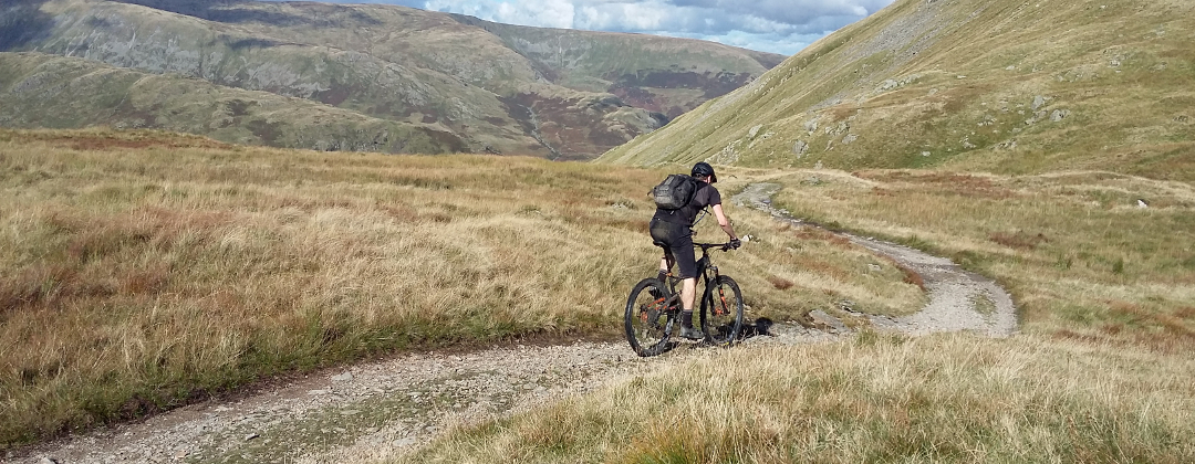
This mountain bike route of 19.3 miles is a great ride for those who like technical Lake District riding. It climbs the Garburn Pass from the Troutbeck side, which is rideable but with a few difficult sections. Descending the Garburn Pass into Kentmere is for those who like steep, technical, boulder strewn descents. Although the Garburn Pass is the first and best descent the rest will not disappoint giving a good mixture of pick your way down boulders and fast blasts.
1. Start from the Mill Yard car park behind Wheelbase Cycles in Staveley (GR471983). Leave Mill Yard by the main entrance and go past the first lane on the right to the junction with the main road through the village. Turn right and follow the road to a short way to the next junction. Turn left and follow the road through the village, in the direction of Windermere, towards a junction with the A591. At a junction at the edge of the village, where the main road turns left to meet the A591, go straight on up the dead end lane in the direction of the signs for Cycle Route No 6. Where the lane ends follow the cycle track ahead through the trees, and then along the right hand side of the A591. Continue along this track to where it ends at a junction with the third lane on the right, on the far side of Ings (GR442988).
2. Turn right and climb the lane all the way to the top, going past junctions with two lanes on the left. After reaching the top follow the lane through a small wood and past a third lane on the left. At the junction directly on the far side of the wood bear right up a wide gravel track where the lane turns left (GR423006). Climb the rocky track straight on, going past Dubbs Reservoir, to where it ends at a junction with the Garburn Pass (GR420031).
3. Turn right to a gate. Go through the gate then climb the rocky double track to the top of the ridge. There are a few steep, rocky sections on this long climb to try and clean. At the top follow the track left through a gate then go down a short descent. At the bottom follow the main track right and climb across the ridge to the top of the Garburn Pass (GR436043). Go straight on over the ridge then descend a short way to a gate. After the gate descend the Garburn Pass all the way down to the village of Kentmere. There are two long, steep sections of boulders with a short plateau in the middle. At the bottom of the second boulder section the track flattens off and goes through a couple of gates before bearing right and descending to a lane (GR454044).
4. Turn left on the lane then, a short distance later, follow it right and descend to the church. Follow the lane left around the church then descend to a bridge over the stream at the bottom. Go straight on over the bridge to a junction with a singletrack lane on the left just after (GR458039). Turn left and climb the lane to where it ends at a T-junction. Turn left and climb the lane all the way at a gate at the crest. After the gate descend the lane to a junction on a left hand bend with a wide gravel byway on the right signed to Sadgill (GR465050).
5. Turn right and climb the rocky double track through a couple of gates. At the top the track comes to a gate in a stone wall in the saddle between the peaks. Go through the gate then descend ahead on the double track down the other side of the hill. Take care of your speed on this descent. About halfway down the track bears slightly right to follow the course of a stream. Very soon after this is a sharp left hand corner. Overshooting this corner will put you into deep the rocky stream. After the sharp left descend the steep cobbled bends to a junction at a gate (GR481051).
6. Turn right and descend through the ford then climb the track to a gate. After the gate climb the steep, grassy track across the flank of the hill. The track gradually bears right, eventually reaching the top of Cocklaw Fell for a moorland crossing that can be quite boggy. After a while the track descends left around Skeggles Water before flattening out and coming to a junction by some large boulders and a bridleway marker post (GR473034).
7. Turn right and climb the thin rocky track up the left hand flank of Green Quarter Fell, going past a derelict stone building on the left. Once over the top go straight on down a rocky track to a gate in the drystone wall ahead. Go through the gate and follow the rutted grassy track. The track soon bears right and descends across the side of the fell towards Kentmere, going through a couple of gates on the way. The track is fast and soon becomes quite rocky. About 2/3rds of the way down the track bears left through a gate and descends to a junction at the high stone walls (GR462036). Turn right and descend between the stone walls, going straight ahead all the way to where the track ends at a gated junction with a lane at the edge of Kentmere (GR461040).
8. Go through the gate then turn right and climb the lane to the next junction, then bear left and descend to the following junction (GR461042). Turn left and descend the previously climbed lane to the junction at the bottom. Turn right and go over the bridge then climb to a junction with a bridleway on the left at the far corner of the church. Turn left and descend the double track straight ahead to Kentmere Hall (GR451042). At the junction directly before the Hall go left through a gate then across a stream. After the stream climb the wide rocky track above Hall Wood on the left. At the top of the climb the track bears right to follow a drystone wall on the left. Go through three gates on this undulating trail to a junction at a ford, directly after the third gate (GR443027).
9. Turn left and follow the track along the left hand side of the stream. After going through a couple of bends and a ford the track climbs over a crest before reaching a gate. Go straight on through the gate for a grassy start to the Croft Head descent. Go straight on through the next gate, where the grass gives way to a gravel track as it goes through the next ford. Continue descending the gravel track all the way to some buildings at the bottom, where it becomes a lane. Follow the lane straight ahead for a while then go through a left hand bend to a junction just before a bridge (GR455012).
10. Turn right through the gate and follow the rocky double track along the right hand side of the river. The track eventually bears right and climbs to some buildings. Climb straight ahead between the buildings, going past the right hand side of the house and up a short, steep finish to a junction with a lane (GR454007). Turn left and descend the lane on the right hand side of the river to a junction with a bridge on the left. Go straight on and follow the lane back into Staveley. Follow the lane straight on through the village to a forked junction at a white house ahead (GR470986). Follow the singletrack lane ahead on the left to where it ends at a junction with the entrance of the Mill Yard car park on the left. Turn left into the car park to complete the ride.
Not only is there a bike shop at the start of the ride, there is Wilf’s café, Hawkshead Brewery and More? Artisan Bakery. Not far away in the village is a Spar and local shop, both good for buying trail food.