
Dolgellau and Rhydcriw
North Wales Mountain Bike Route Guide
Region:
Snowdonia, North Wales
Difficulty:
Difficult
(Requires advanced skills and fittness)
Distance:
30 miles
Map:
OS Landranger 124
Route Text Download:
Dolgellau and Rhydcriw
GPS Download:
GPX and KML
(available via the full MapMyRide page for this route, on the right hand side of the page)
ViewRanger
Dolgellau and Rhydcriw Route
Back to North Wales
Route Guides
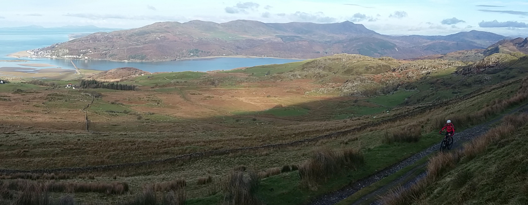
This mountain bike route of 30 miles starts on the outskirts of Dolgellau in Wales, just south of Coed-y-Brenin. It follows a figure of eight route along the north and western flanks of Cadair Idris. There is a good mixture of trails from rolling double track to technical rocky sections with a nice bit of singletrack thrown in. There are also a few of long sections of tarmac but they are mostly on (big) climbs, accompanied by the stunning mountainous scenery of southern Snowdonia and the Irish Sea.
1. Start from the Mawddach Trail car park just outside Dolgellau on the junction of the A493 and A470 (GR714182). Use the road exit of the car park and turn right on the marked Mawddach Trail cycle track, on the path to the right of the road. Almost immediately follow the cycle track left across the road then straight on along the left hand side of the river, in the direction of Dolgellau. After some time follow the cycle track right across a bridge over the river. At the junction on the far side of the bridge turn right then follow the thin concrete path up the side of the stream. The path ends at a junction in a lay by on a road at the outskirts of Dolgellau (GR721178).
2. Turn left and follow the road into Dolgellau to the second junction with a road on the right, by a garage and a bus stop (GR725176). Turn right and climb the steep lane out of Dolgellau. Follow the lane straight ahead out of Dolgellau, to the second junction after the last houses, a forked junction with a lane dropping away to the right (GR715169). Bear right and descend the single track lane, which soon flattens out, to a junction with a short, rocky double track on the left, leading to a gate by a derelict building (GR707167).
3. Turn left and follow the track to the gate. After the gate turn right and climb the very steep grassy track to the gate by the trees at the top (GR705166). After the gate go straight on and follow the grassy and rocky track as it climbs across the top of the hill. After a while the track goes to the left of a small mound and through a shallow dip before gently climbing to a gate. After the gate continue following the track straight ahead as it becomes progressively more rocky and starts descending. While this long downhill doesn’t have a steep overall gradient there are a few steeper bits with some quite technical riding over big rocks. Keep following the trail straight on until it comes to a gate at a house. Go through the gate then straight on through the next gate directly after. After this go right over a low crest then bear left on the steep, loose trail down through the trees to where it ends at a junction (GR686159).
4. Bear left and climb the wide track to a left hand bend. Go right through the gate on the outside of the corner for an off camber, rooty singletrack trail across a steep slope through the trees. After a tight right go over a low crest then descend to a stream crossing. After the stream climb off to the right then a short distance later go left to a junction with a wider grassy track at the bridleway marker post (GR688157). Turn left and climb the steep grassy track that soon bears right to follow a dry stone wall on the left. The track then bears left past a rock face on the right before coming to a steep grassy field. Bear right and push up through the field to a gate in the top right hand corner. After the gate descend through a shallow dip, then over a low crest before jinking right through the trees to the gate straight ahead. Go through the gate then follow the double track to a farm. Go straight on through the gates at the farm then at the lane junction just after bear left. Follow the lane straight on all the way to where it ends at a junction by a car park (GR698152).
5. Turn right and follow the lane for a long gradual climb up the left hand side of the valley beneath a stunning rocky ridge. At the top bear right to a junction (GR663135). Turn left and follow the lane past a derelict building on the right. Descend the lane to a junction in a dip, after crossing the stream, with a broken track on the left (GR656113). Bear right and climb the lane. After a while go past a grassy double track leading to a gate in the wall on the right, taking note of it for the return leg, and continue climbing straight on to a crossroad junction, with a gated track on the left and a lane descending to the right signed as 25% (GR648133).
6. Go straight on along the lane, which soon drops into a dip by some buildings and a wind turbine. Follow the lane left as it climbs to the forest. Continue following the lane straight ahead through the trees to a gate at the standing stone on the other side. Go through the gate and over the top of the hill then descend the straight lane all the way to a junction with a double track straight on, where the lane descends right (GR607108).
7. Go straight on and follow the double track of the Wales Coast Path as it contours along the hill, accompanied by fantastic views over Barmouth, Snowdonia and the Irish Sea. Keep following this track for some time then go through a gate and descend bearing slightly left. At a stone wall the track bears right and becomes quite rocky until it reaches a junction with a lane (GR598101). Continue straight on and descend the lane for a short while, going past an access track to the farm buildings on the right, before reaching a junction with a grassy track between two widely spaced stone walls on a left hand bend (GR596100).
8. Turn right and descend the grassy track, which soon bears right before coming to a small gate at the trees. Go straight on through the gate and descend the thin rocky track through the trees. Follow it down through a left then right hand bend by to a gated junction by a house on the left. Turn left through the gate then go straight on down the lane to where it ends at a junction with the main coast road (GR592101).
9. Turn left and follow the road through Llwyngwril to the junction by the cemetery at the far side of the village (GR591093). Turn left for a long and very steep climb that eventually comes to a T-junction (GR591080). Turn left and follow the lane across the top of the hill until it come to a junction at two buildings, one a derelict house and one a barn, where the lane turns right (GR588072).
10. Turn left and go through the gate on the grassy track leading to the derelict house. Directly after turn square right and follow the track down the left hand side of the barn. Go straight on and descend the track, along the fence on the right, towards the sea. After the next gate the track becomes muddy singletrack that can be quite slippery in the wet. Halfway down the track comes to a junction with a gated, muddy double track on the right (GR589067). Go straight on past this down a steep, grassy and muddy track, which then bears right to a gate. Go through the gate for more muddy singletrack that descends through the gorse. The track ends at a gate by a house that leads on to a lane (GR592064).
11. Go through the gate and follow the lane ahead to the next junction then follow the lane right. After descending through a number of bends the lane bears left past a cemetery before coming to an end at a T-junction (GR597057). Turn left and climb the lane to the next junction with a tarmac track on the right signed as a bridleway (GR599059).
12. Turn right and descend the track to a house. At the three-way just on the far side of the buildings take the thin grassy track ahead and descend through the bushes to a gate a short distance later. Go through the gate and into a field. Stay high and go across the field to the second gate in the fence on the right (GR602061). Go right through the gate then down through the field keeping to the fence on the right. At the bottom of the field go straight on through the gate, past a farm on the left, and follow the double track to a junction with the lane at the bottom (GR605058).
13. Turn left and follow the road along the bottom of the valley to the next junction, with the white stones (GR610060). Turn left to start the longest climb of the ride. It is a tarmac climb all the way to the top. About halfway up the lane bears right then goes over a cattle grid before coming to a forked junction (GR623073). Go straight on, past the track descending to the right, and continue climbing the lane. After bearing left the climb finishes with a long right hand bend that leads to a small stand of trees at the top (GR625088).
14. Follow the lane left past the trees then go straight on over the top and descend the gravel double track. The track descends to the previously visited junction on a right hand bend (GR628096). Bear right and retrace your wheel tracks. Follow the double track along the flat then through the left hand hairpin before climbing to the forest at the top. At the top continue straight on along the wide track all the way back to the gate at the edge of the trees, with the stunning view across the Mawddach Estuary. Go through the gate to start the long, fast double track descent. After going through the second gate on the descent, at the top of a small rise, descend the broken tarmac to the previously visited gated junction on a right hand bend (GR648129). Go past the gate and descend through the right hand bend. Continue descending the track through a number of gates to where it ends at a junction with a lane (GR656133).
15. Turn sharp left and climb the lane to the next junction, with a grassy double track leading to a gate in the wall on the right (GR654134). Turn right and follow the double track through the gate. Directly after the gate descend the double track left then right, past the small stand of trees, before coming to a house. Follow the track right, around the back of the house, to a junction at a ford. Turn left directly before the ford and follow the double track along the left hand side of the stream. After passing a stone bridge on the right the track goes up a short climb to a gate. Go through the gate and on to where the track ends at a junction with a steep lane (GR648138).
16. Turn right and descend the lane, going through the gate halfway down, to a junction with a gated double track ahead where the lane descends steeply to the right (GR645140). Go straight on through the gate then at the forked junction directly after take the right hand track. Descend gently to the next junction and go through the gate on the right that leads to a cottage. Go straight on past the cottage, where the trail steepens and comes to a gate. Go through the gate for a very steep, rocky and tight winding trail down through the trees. Keep to this trail all the way down, going past a gate on the right on the upper section. Lower down go through a few gates to eventually reach the end of the trail at a junction with a lane. Turn right and descend a short distance to a junction with the main road (GR637141).
17. Turn right and follow the main road for a short distance to a junction with a track on the left, near the end of a right hand bend in the road (GR638143). Turn left and descend through the gate then follow the grassy track to a crossroad junction with the Mawddach Trail (GR637144). Turn right and follow the Mawddach Trail all the way back to the car park at the junction of the A493 and A470 to complete the ride.