
Hebden Bridge – Singletrack Route
Yorkshire Mountain Bike Route Guide
Region:
Calderdale, West Yorkshire
Difficulty:
Moderate
(For Experienced Riders)
Distance:
23.5 miles
Map:
OS Landranger 103
Route Text Download:
Hebden Bridge – Singletrack Route
GPS Download:
GPX and KML
(available via the full MapMyRide page for this route, on the right hand side of the page)
ViewRanger
Hebden Bridge – Singletrack Route
Back to Yorkshire
Route Guides
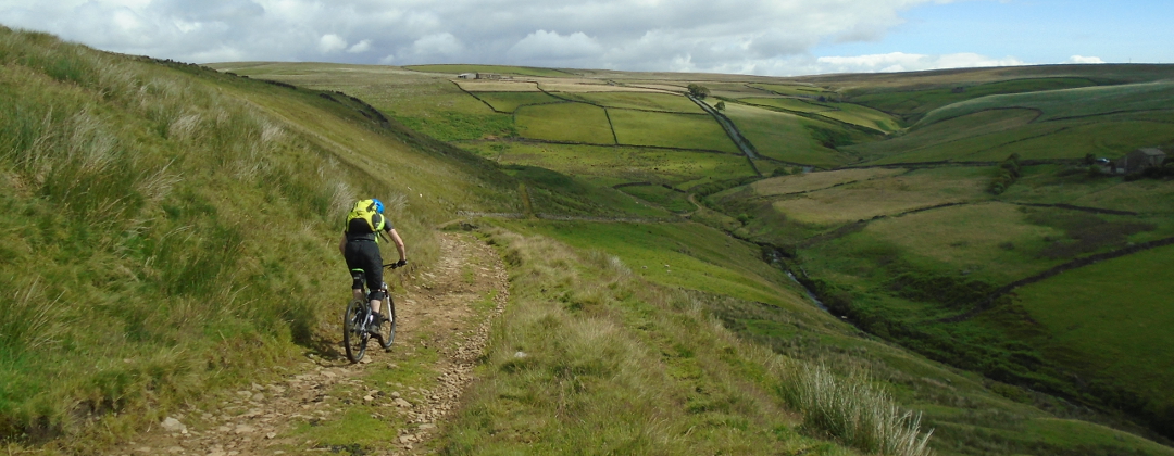
This is a mountain bike route of 23.5 miles that I first came across in Singletrack magazine. It starts in Hebden Bridge and follows a big loop to Todmorden and back. It contains some great riding. The first half of the route takes in the moors and reservoirs of the area. Then the second half drops through Calderdale, past the outskirts of Todmorden, following the packhorse trails and singletrack that criss-cross the valley on the way back to Hebden Bridge.
1. Start from the car park in the centre of Hebden Bridge, just over the bridge from St George's Square, near the A6033 (GR992274). Leave the car park from end furthest from the toilet block then turn left and go across the bridge to St George's Square. At the square turn left to a junction with the A6033 a short distance later. Turn left and climb the A6033. At the traffic lights go straight ahead and continue up the A6033. After the lights take the third road on the left, at a four way junction, signed for Hardcastle Crags (GR993280).
2. Follow Midgehole Road all the way to the public toilets, just before the entrance of the National Trust car park (GR988291). Directly after the toilets turn right up a thin track between the dry stone walls, signed as a bridleway. At the junction at the top turn right and climb the lane up the left hand side of the valley. The lane soon becomes a gravel track as it re-enters the trees. Climb straight on past all the tracks on either side. After leaving the trees behind continue up the valley and go through a gate, by a farm on the right. This leads on to a flat section of trail that comes to a junction with a gate on the left, by a derelict building (GR989313).
3. Turn left through the gate for a short, steep, grassy and muddy climb between the drystone walls. Go through the gate at the top and follow the singletrack ahead, along the wall on the left. After a short distance go through a small gate in the drystone wall on the left and into a field. Turn right and descend through the field keeping to the wall on the right. 3/4 of the way down the field, after a boulder launch pad on the left, the track becomes more defined and goes through a gate. After the gate the track climbs a short distance before dropping right to another gate (GR974313).
4. Go through the gate then straight on between the buildings and through a couple of bends on the far side. This leads to a straight wide dirt track that eventually comes to a couple of gates by a farm building on the left. Go through the small gate on the left of the large gate and continue along the track. The track soon descends through a left hand bend to a gate at a stone bridge. Bear right away from the bridge and climb past a track on the left up the concrete double track. At the triangular junction at the top turn left then left again, onto the lane by the trees (GR954325). Go over the crest then descend to a right hand bend that leads to a gate. Go through the gate on the left to descend a grassy track to the road junction (GR946324).
5. Turn right and climb the lane to Widdop Reservoir. After the lane flattens off go past a car park on the left to a gate in the stone wall on the left that leads onto the Widdop Reservoir Dam (GR937329). Turn left through the gate and ride along the cobbled track across the dam. On the far side turn right and follow the grit stone track along the left hand side of the reservoir. The track soon begins to climb, getting steeper as it goes. Follow the trail up through a number of bends, bearing left at the junction on the steep left hand hairpin (GR926324). The track then turns right and climbs through some very loose rocks before flattening off at the top of the hill. Follow the track as it bears gently right to a short descent over a section of bedrock. After descending the rocks traverse the hillside on the gritstone track to a gate (GR915320).
6. After the gate descend the track to a water bar, which is good for some air, directly before a small bridge on a left hand bend. Go up a short climb then, at the top, follow the trail right for a long rocky decent that is dotted with more water bars, fun ones you can jump. The descent flattens off and comes a junction directly before a gate ahead (GR895324). Take the track on the left for short, winding descent. After crossing a small bridge the descent finishes on the left hand side of Hurstwood Reservoir. Follow the track by the side of the reservoir to a junction at the far end (GR889314). Turn left, then at the forked junction immediately after go left again and climb the track past the pylon. At the junction at the top of the climb follow the main trail as it bears right then descends to a junction at Cant Clough Reservoir (GR894310).
7. Go right through the gate then left to ride over the dam. Go through the dip on the far side to a gate. After the gate follow the main trail off to the right. This goes through a few bends before descending to a bridge and a junction directly after (GR891302). Turn left and follow the trail to a rocky ford. After crossing the ford climb the rocky trail alongside the wall on the right. Bear right through the next stream crossing, using either the bridge or the ford. Climb between the walls, through a number of bends, to the next junction. Take the singletrack on the left that goes under the trees before a grassy climb to the car park by the Coal Clough wind farm (GR894288).
8. Go through the car park then turn left onto the main road. The road climbs for a while before flattening off and going through a left then long right hand bend around a bowl in the hillside. At the next junction with a lane on the right, where the main road bears left, turn right following the sign for Todmorden (GR915276). Descend this steep lane a short way to a junction by a house on the right (GR914273).
9. Turn left onto the dirt track and descend through an ‘S’ bend to a farm. Take the muddy singletrack off to the left, just in front of the house. The track soon firms up and also speeds up. Go straight across the crossroad and descend the rocky, grit stone track. At the bottom negotiate the muddy right hand bend then go up a short climb. If wet it can be difficult to find a line on the corner that is not ankle deep gloop. The trail bears left through a gate for the next boggy section of the ride, again in the dry it is ok but in the wet it is hard going, although still rideable. It soon dries out and descends to the next gate. After the gate follow the trail up a short rocky singletrack climb that then flattens off and leads on to the final boggy section of this trail. Once through the mud and the following gate bear right to the worn flags of a packhorse trail. Descend to the next gate then go straight on and descend the uneven, teeth rattling rocks of the packhorse trail to a gate. After the gate descend the track a short distance to a junction with a lane (GR937257).
10. Turn right and descend the steep gravely lane, over the water bars and around a left hand bend to the next junction (GR940254). Go straight across and head up the gritstone trail that bears right and climbs steeply between the stone walls. The trail soon bears left and flattens off. Continue straight on after emerging from the trees and descend the tight, rocky singletrack that ends at a junction. At the junction bear left up a short gritstone climb, by a stone wall on the right, then descend to a muddy section that leads on to a golf course car park. Go straight on through the car park to a junction with a lane (GR946249).
11. Turn right and descend to a junction in the village. Turn left and ride past the church. After passing a graveyard and house on the left take the track on the right directly after a stone house on the right (GR950249). Follow the singletrack in a straight line as it descends across the top of a big drop on the right. The trail becomes twisty as it enters the trees then finally comes to an end after going through a right hand hairpin and climbing to a junction (GR956251).
12. Turn right and follow the wide gravel track through a left hand bend to a junction at the buildings (GR957249). Turn right and ride into the tight cluster of stone buildings. Keep following the left hand wall to a section of singletrack leading off from the left hand corner of the courtyard. This leads on to a great descent that has a steep, pick your way down rocky start and then speeds up as it goes through a left then right hairpin to end at a car park at the bottom (GR956247).
13. Turn left out of the car park onto the main road (A646). Follow the main road a short distance to the next junction with a lane on the right signposted to the Youth Hostel (GR960248). Turn right down this lane and cross the bridge over the river. Follow the lane through a couple of bends then go over the canal. Bear right directly after the canal then at the end of the houses go up through a steep left hand hairpin to begin the long climb out of the valley. Climb the lane through the trees, going straight on past the junction to the Youth Hostel, to a junction at the bottom of a housing estate (GR962240).
14. Bear left up the second lane from the left and climb between the houses. After leaving the houses keep climbing ahead. The lane becomes a dirt track on the way up before ending at a gated junction with the Mary Towneley Loop (GR964236). Go through the gate and turn left then follow the hardpack track as it traverses the hillside underneath the Stoodley Pike monument. Go straight on at the next junction. The trial then bears right and climbs, becoming increasingly rocky. At the junction just after the power lines continue bearing right and climbing. After a while go through a left hand bend, then a gate, and up the rockiest part of the track to a gate by a farm at the top (GR981248).
15. After the gate descend the track to the following junction and go straight on along the broken, pot holed tarmac. Go past the next farm buildings to the next junction. Go straight across the crossroad to the next junction (GR989263). Turn left and descend the broken, rocky track. At the bottom turn right and descend the broken tarmac, taking care at the farm buildings a little further on. After the farm turn left to follow the lane as it steepens and drops into the valley. What happens next can get a bit scary as the tarmac suddenly gives way to a section of steep cobbles. They don’t give much grip in the wet. This thankfully gives way to concrete just before going through a blind right then left hand hairpin. After the hairpins continue ahead down to the junction at the bottom of the lane, in Hebden Bridge (GR996267).
16. Go straight over the junction then along the very broken tarmac, passing the railway station on the left, and under the bridge. After the bridge follow the lane left and climb a short way to the junction at another bridge. Turn right and cross the canal to the junction with the main road (GR995270). Turn left and follow the main road to the next junction and turn right on the A6033, signed to Haworth and Keighly (GR994271). Climb from the junction then take the second road on the left, in the bottom of a dip. Follow the road a very short way to St George's Square then turn right across the bridge and return to the car park to complete the ride.