
Parkamoor – Claife Heights
Lake District Mountain Bike Route Guide
Region:
Hawkshead, Southern Lake District
Difficulty:
Difficult
(Requires advanced skills and fittness)
Distance:
23.7 miles
Map:
OS Landranger 96
Route Text Download:
Parkamoor – Claife Heights
GPS Download:
GPX and KML
(available via the full MapMyRide page for this route, on the right hand side of the page)
ViewRanger
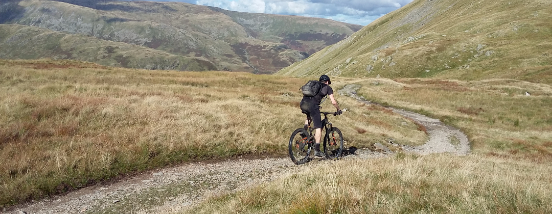
Parkamoor - Claife Heights Route
Back to Lake District
Route Guides
This mountain bike route of 23.5 miles starts from Hawkshead in the southern Lake District. It begins by following The North Face Trail before leaving Grizedale Forest for lots of natural rocky riding, which includes the Parkamoor descent and Claife Heights.
1. Start from the car park in Hawkshead (GR353981). Head out of the car park, away from the buildings, to the main road. At the main road turn left to skirt around the edge of the village. Go past the first lane on the left and follow the main road round a left hand bend to the next junction, where the main road turns right (GR352983). Turn 90deg left into Hawkshead. Follow the lane to the start of the pedestrian zone then turn right. Go straight on through the arch way in the building ahead. Climb out of the village and up to a junction by a B&B on the left. Go straight on and climb the rocky track ahead, keeping the steam on the left. At the gate some distance later follow the bridleway up the steep, rocky section of trail straight ahead. The track then goes left through a water splash then right, where it climbs to a junction with a fire track (GR343977).
2. Turn left and climb the fire track then start following the arrows for The North Face Trail. After the fire track goes through a right hand bend turn left halfway up the long straight for the first bit of manmade singletrack. At the end of this track go straight across the three-way fire track junction. At the next junction turn right then almost immediately left for the next bit of North Face singletrack. At the end of this trail keep following the North Face Trail arrows right then left along the fire track. Eventually turn left for the next bit of singletrack that descends to the Grizedale visitor centre (GR335944).
3. At the centre turn left then right over the bridge. Go through the wall and around the right hand side the adventure play ground to the lane after the wall on the opposite side. Follow The North Face Trail right on the lane then left through a gate to climb a wide hardpack track into the forest. At the next junction turn right then a short distance later turn left to climb the 'Elephants Paradise' singletrack. At the end of 'Elephants Paradise' follow The North Face Trail left along a wide forest track. Go straight across the following crossroad junction to the next section of singletrack, 'The Great Escape', on the left. At the end of this singletrack rejoin the forest track and go straight on to a crossroad junction (GR323935).
4. Leave The North Face Trail and go straight on to climb the rocky double track. After negotiating some tricky rock sections the track flattens off and rejoins the fire track. Go straight on to the junction just ahead then turn left and descend to a triangular junction (GR318930). Go past the first track on the right then straight across the following crossroad. There are then two choices, either straight on up the fire track or right on a boggy double track bridleway. If it has been wet go straight on up the firetrack to the next crossroad then turn right and follow the bridleway to a gate at the edge of the forest. After the gate follow the rocky double track as it undulates through a number of puddles across High Parkamoor. The bridleway alternative rejoins this trail halfway down on the right (GR312925). The bridleway option is muddy and boggy with deep ruts that fill with water, only use it if it has been dry for some time.
5. Follow the double track as it bears left over the top of the hill, with great views across Coniston Water, then descend to a junction with a track on the right (GR306925). Go straight on along the double track as it undulates across the side of the fell. After a while the track points down hill for the fantastic, rocky Parkamoor descent. It's very technical in places with drops, loose boulders, tight corners, water and the opportunity for quite a bit of speed. The descent ends at a gate in High Nibthwaite (GR294897).
6. After the gate go straight on to a junction with a lane. Turn left and follow the lane along the bottom of the valley. Go past a lane on the right then at the following junction, at Nibthwaite Grange, turn left (GR296881). Climb the steep lane though a number of bends to a junction with a forest track on the left, at the top. Continue along the lane to a junction at the end of the tarmac a little further on (GR305888).
7. Go straight on through the gate and along the double track, keeping the trees on the left, to a gate a little further on. After the gate bear right and follow the signposted bridleway. There are usually some long, deep puddles on this section of track. After a short descent climb through a gate and continue straight up the rocky double track, past the grassy bridleway signed off to the right. At the top of this short climb the track flattens off for a while before it heads down hill for another fun, rocky descent that ends at a gated junction with a lane (GR323894).
8. Turn left and descend the lane until it ends at a junction. Turn left again and follow this lane all the way to village of Force Mills at the bottom. Go right then left over the bridge and climb past the waterfall on the left. Go past a track on the right to a junction where the lane turns left (GR341911). Go straight on at this junction then past a car park and picnic area in the trees on the left, before descending to the next junction (GR345913). At this junction turn left on the wide forest track into the trees. Climb through a tight left then right hand bend, ignoring any of the tracks off to the side. Continue climbing up the wide track to the four-way junction at the top (GR344918). Go straight ahead on the singletrack leading into the trees. This reaches the top of the climb a short distance later before going over a rocky drop that marks the start of a loose and rocky descent to a junction at the bottom in Satterthwaite (GR340921).
9. Go straight on around the left hand side of the house, and follow the lane straight on into the village. Bear left at the church then turn right at the junction. A short distance later, where the main road bears left take the thin lane on the right to go straight on between the houses. A short distance later at the next junction (GR338924) turn right and climb the steep lane past a private drive on the left. The lane then bears left and climbs to a junction at a house at the edge of the forest (GR339926). Take the first track on the right for a steep, rocky climb into the trees. About 1/4 of the way up bear right to cross a stream then follow the track left around a big section of exposed bed rock for a straight, loose and rocky climb to a junction at the top (GR345929).
10. Go straight across the junction and head along the singletrack that undulates along the line of the hill and bears left. The track soon heads downhill for another fantastic descent. The trail drops over some rocks and comes to a junction with a forest track (GR349932). Go straight across this junction and down some more rocks to head into the trees. What follows is a great section of rocky and rooty woodland singletrack before some tight, loose and rocky corners that lead to the junction with the lane at the bottom (GR354937).
11. Turn left on the lane and climb to a bridleway signposted off to the right halfway up, where the climb flattens off slightly (GR355939). Turn right down this bridleway and descend to a stream crossing. Go across the stream and climb off to the right and follow the track to a gate leading into a field. Climb across the field to a gate at the top right hand corner. After this gate continue climbing on a rocky track through the trees to a four-way junction at a fire track. Go straight across the junction to continue along the singletrack. At the top bear left down a fast hard pack track that soon becomes loose and rocky with a couple of tricky technical sections. The descent ends at a junction with a road (GR365944).
12. Turn left and follow the road to the next junction, just before Esthwaite Water (GR362952). Turn right, then after crossing the river climb to the next junction. Bear left towards to the village of Near Sawrey. At the next junction, on the edge of the village, bear right and climb to the junction at the end of the lane. Turn right and ride through the village to a junction with a lane on the left, just before the last house on the left (GR370956).
13. Turn left and climb past the farm on the left, to where the tarmac gives way to a gravel track. Follow this track uphill and go straight on through the next farm buildings. At the following junction bear left (GR373961). Go straight on at the next junction, with a track on the right, and continue climbing. At a junction with a gated, private track bear right and climb the double track to Moss Eccles Tarn. After the tarn climb the rocky double track past some tracks on the right then descend towards the next tarns. The track then bears right around a small tarn on the right and climbs up a section of steep grass towards the trees. At the top follow the trail along a wall on the left to a gate at the trees (GR373977).
14. Go straight on through the gate and follow the wide forest track. After the track bears right it descends to a forked junction where the main forest track bears right downhill and a bridleway is signposted bearing left down a loose rocky track. Follow the bridleway left down the loose, rocky track to a crossroad a short distance later. Turn left and follow the signposted bridleway in the direction of Hawkshead. Descend the wide forest track down to a tight right hand bend at the bottom before climbing to the next junction (GR375986).
15. Turn left to follow the signpost for Hawkshead and climb the rocky track a short way to the top of the hill. Stay on this track and go straight on past the footpath on the right. At the top stay on the obvious trail in front for a fast, fun, rocky track that generally bears right around the hill. Some way down is a small forked junction, stay right. Further down follow the track through a wide, steep and rocky left then right. The descent eventually ends a junction with a lane (GR359985). Turn left on the lane and follow it as it winds down hill, past a couple of lanes on either side, until is ends at a junction with the main road (GR355981). Turn right and go over the bridge, then at the next junction turn right again. Follow the road for a short distance to the next junction then turn left and return to the car park to complete the ride.