
Helvellyn
Lake District Mountain Bike Route Guide
Region:
Glenridding, Eastern Lake District
Difficulty:
Difficult
(Requires advanced skills and fittness)
Distance:
13 mile
Map:
OS Landranger 90
Route Text Download:
Helvellyn
GPS Download:
GPX and KML
(available via the full MapMyRide page for this route, on the right hand side of the page)
ViewRanger
Helvellyn Route
Back to Lake District
Route Guides
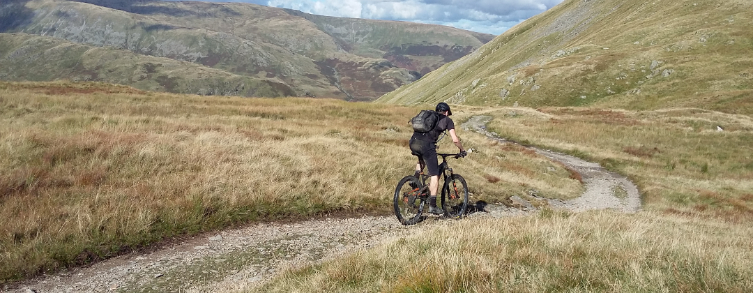
This is a mountain bike route of 13 miles over Helvellyn, in the Lake District, on the highest bridleway in England. It climbs Sticks Pass and descends Dolywagon Pike and Grisedale. With steep boulder covered descents and long sections of hike’a’bike this ride is a very big test of your stamina and riding skills.
1. Start from the Ullswater Information Centre car park in the middle of Glenridding (GR385169). At the car park exit turn right to another junction immediately after. Turn left, then follow the road through a gentle right hand bend to a junction with the main road (GR386171). Turn right and follow the road to a junction with a lane on the right immediately after crossing the bridge over the river, Ulls Water, and before the shops (GR387169). Turn right and follow the lane up the left hand side of the river. After leaving the houses continue ahead through the trees to a junction with a track descending off on the right. Turn right to stay by the river and follow the rocky track all the way to Gill Side Farm campsite. Go straight on through the campsite to a junction with a lane, by a bridge on the right (GR379169).
2. Turn right and follow the lane across the bridge then climb to a junction at the top edge of Glenridding (GR381170). Turn left and climb steeply up the lane, bearing left to where it gets less steep at the row of houses on the right. After the houses the lane becomes a double track that climbs ahead up the right hand side of the valley to Helvellyn YHA. Go straight on past the YHA to a junction with a gate ahead (GR365173). Turn right and climb the steep, rocky track that goes through a number of wide, loose bends. After the final left hand bend the track comes to a junction with a steep grassy trail on the right, signposted to Sticks Pass (GR362174).
3. Turn right and climb the grassy trail to where it ends at a junction with a rocky trail. Turn right and climb the steep, rocky trail. A short distance later the trail climbs through sharp left hand bend, the first of a few bends on the way up. After the second right hand bend the trail becomes a definite hike’a’bike, no matter how good at climbing you are, across the face of the slope. The trail eventually comes to a junction at a large pile of boulders, on the left, where the trail ahead flattens off (GR362177). Turn left and climb through the boulders. The trail soon goes through a right hand bend and becomes grassy. Follow the trail ahead, which eventually climbs through a left hand bend before flattening off and becoming rideable again. At the top follow the track straight ahead until it descends to a bridge at the bottom of the old earth works (GR359180).
4. Go across the bridge then on the far side climb left across the sand. At the top of a short climb go straight ahead and follow the track across the bottom of the valley. At the far side turn left and follow the singletrack trail up the right hand side of the valley. This is a great trail dotted with tricky rock sections to try and clean. Towards the end the trail becomes an increasingly steep hike’a’bike out of the valley. At the top the track flattens off before coming to a crossroad junction on the ridge, a good spot to refuel (GR342182).
5. Turn left to head south along the ridge path, keeping an eye out for the cairns that mark the direction of the track, and climb towards the summit of Raise. Eventually the climb becomes a hike’a’bike up a rocky track to the top. Go straight on over the top then down a short drop to a rock strewn plateau. Bear slightly right then go across the plateau to where the track becomes more defined on the far side. Descend through some steep loose corners before a fast straight blast to a junction at the bottom (GR339169). Go straight on through the dip then up the steep track to the top of Keppel Cove. Go straight on over the summit and descend the rocky track to the bottom of the Lower Man climb. Go straight on up Lower Man, which soon becomes a long hike’a’bike. Remount at the top and descend to a junction then bear left and climb the wide track straight ahead all the way to the trig point at the summit of Helvellyn (GR342152).
6. Turn right from the trig point, so the cliff edge is on the left, and follow the ridge to the stone shelter, which is another good place to refuel. Go straight on past the stone shelter and descend the wide, rocky track south along the ridge. At the following forked junction, after about 1/3 mile, turn left for a short climb up a wide, rocky track (GR342145). At the top continue straight ahead on the multiple lines across the lumpy, rocky plateau. After a while the trail starts descending, lower down bearing left into a dip. At the bottom bear right for a short but tricky climb. At the top follow the obvious track ahead that soon bears left to follow the contour of the slope. It then straightens out before going up a shallow climb to the top of the Dollywagon Pike descent (GR346128).
7. Go straight on down the steep, loose and rocky trail. All too soon the trail comes to a very steep and technical section paved with huge uneven boulders, broken by a number of big water bars. I’ve ridden all but a couple of the biggest water bars but it’s a big test of my skills and makes my arms and legs burn….a lot. Just before reaching Grisedale Tarn the trail bears left where the boulder paving gives way to a more natural, but still technical, riding. Continue ahead along this trail until it comes to a junction on a flatter part of the trail at the far end of Grisedale Tarn (GR351123).
8. Go straight ahead between the boulders and descend the first section of bed rock, which is the start of the Grisedale descent. Follow rocky trail ahead, high along the left hand side of the valley. Although this descent is less steep than Dollywagon Pike there are many boulders and sections of bedrock to test your technical riding skills. Eventually the trail comes to a small plateau at Ruthwaite Lodge, about 1/2 way down (GR355135). Bear right from the lodge and continue descending the rocky trail as it gradually crosses to the right hand side of the valley. On the right hand side of the valley go across a small bridge, where the track smooths out for a while before a big section of bouldery fun to finish. At the end of the boulders the trail gives way to a wide gravel track in the bottom of the valley. Continue ahead along the track, going through the gates on the way. When the track becomes a tarmac lane continue straight on. The lane eventually ends with a fast winding descent to a junction with the A592 (GR391162).
9. Turn left on the main road all the way back to Glenridding. Go across the bridge over Ulls Water, in the centre of Glenridding, to the junction directly after (GR386169). Turn left and follow the road to the next junction a short distance later. Turn left again and return to the Information centre car park to complete the ride.