
Conwy and the North Wales Path
North Wales Mountain Bike Route Guide
Region:
Snowdonia, North Wales
Difficulty:
Difficult
(Requires advanced skills and fittness)
Distance:
19.1 miles
Map:
OS Landranger 115
Route Text Download:
Conwy and the North Wales Path
GPS Download:
GPX and KML
(available via the full MapMyRide page for this route, on the right hand side of the page)
ViewRanger
Conwy and the North Wales Path Route
Back to North Wales
Route Guides
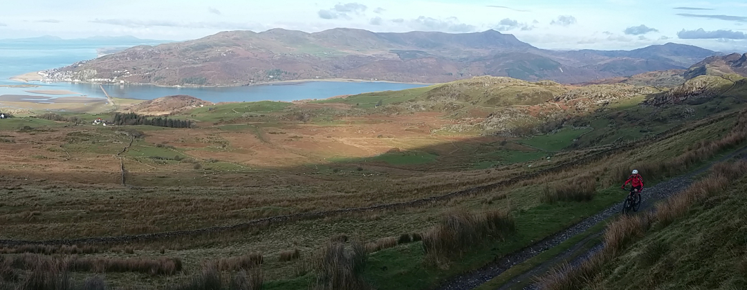
This mountain bike route of 19 miles starts from just outside Conwy in North Wales. The route heads to Llanfairfechen and back around Tal y Fan. The first half contains some hard riding including a steep, loose descent from Llangelynin Old Church and the notorious Rowen YHA climb. The second half is easier as it returns along the North Wales Path, with fantastic views across the coast and the Great Orme, finishing with a long descent from Conwy mountain.
1. The ride starts from a car park at a junction on the Sychnant pass road, by Crow's Nest Hall (GR759769). Turn right out of the exit to the car park and follow the singletrack lane away from the road junction, keeping the hill on the right. Stay on the lane and follow it all the way to where it ends at a T-junction (GR764756). Turn right and start the first big climb of the ride. Go straight on at the next junction then, after a left then right hand bend, go straight on at the following junction. At a junction with a track on the right follow the lane left over a stream, then bear right past a track on the left. Continue climbing the lane to a forked junction at a house (GR754745). Turn left and follow the sign for the chapel. Ignore the next road on the left and continue climbing the tarmac. Near the top of the hill, by a farm on the right, go straight through a gate and onto the concrete track. A short distance later take the muddy track on the left and follow it to a junction at the top of the climb (GR751738).
2. Turn left and descend past the chapel through a number of bends on the grassy double track between the drystone walls. The track soon steepens, becoming loose and rocky, with water usually running down it. Continue descending between the walls as the track gets steeper and rockier. At the crossroad junction at the woods follow the track straight on for a technical switchback descent through the trees. After a right hand bend go straight on to a gate at the edge of the woods that leads to a lane (GR758733).
3. After the gate turn left and descend the lane to the next junction. Turn right and follow the lane along the flat for a while. The road soon starts to climb gently before reaching a junction above Rowen (GR754721). Turn right and climb the lane past the 25% sign. What follows is a very hard climb in two sections, so don't blow all your energy on the lower part. A short, flat interlude leads to the steeper, top section of the climb, which I've been informed is actually 33% in places. This evil climb finishes just after Rowen YHA. Continue straight on when the lane transforms into a rocky track. A tricky boulder strewn start soon gives way to a steady climb on double track. Continue straight ahead along the track, going through a number of gates, to a junction with a lane at the other end (GR732715).
4. Turn right and follow the lane for just under 1 mile to a gate at a car park. Go through the gate and follow the rocky double track in the direction of the pylons. Climb to a gate in the drystone wall on the saddle between the hills. Go through the gate and descend the double track on the other side. After negotiating a few stream crossings, and taking in the views over the coast on the right, climb to a sign posted crossroad junction (GR693722).
5. Turn right, following the sign for Llanfairfachen, along the grassy double track. Follow the track straight on at the junction with a track on the left to stay just to the right of the low peak on the ridge. The track then descends steeply to a junction. Turn left and descend steeply on the grass. Bear right around the hill keeping high of the drystone wall on the left. When the wall comes up to meet the track continue straight on and stay by the wall. Keep close to the drystone wall on the left and descend to a metal gate. Go through the gate and finish the descent on a steep section of bedrock that leads a gate and a junction with a lane (GR682739).
6. Turn right and follow the lane for just under 1 mile. The lane bears right up a gentle climb before descending to a junction with a lane on the left (GR692740). Turn left and descend the lane then go across the bridge. Turn left at the junction on the other side then a short distance later, at the following junction, turn right up a steep tarmac climb (GR693741). At the junction where the lane turns left over a small bridge, go straight on and climb the gravel track a short way to a gate at a junction with a lane. Turn left on the lane and continue climbing to a junction with the hedge directly ahead. Turn left and follow the lane for a short distance to the junction by the houses (GR696747).
7. Take the first turning on the right and climb the lane with the footpath sign pointing up it. At the next junction take the track ahead, on the left, and go through the gate (the right hand track is a driveway that descends to a house). After the gate climb the track that is a bridleway section of the North Wales Path. Go straight on at the gate by the farm and continue climbing through a couple more gates as the track becomes grassy and bears right following the fence on the right. Near the top of the climb bear left to a gate. After the gate climb gently straight on up the grassy double track. Stay on this track and head towards the saddle between the hills ahead and on the left. At the saddle the track comes to a junction with a footpath coming in from the left (GR718747).
8. Bear slightly right and follow the drystone wall on the left. When the grassy double track bears right to the ridge, turn left at the bridleway marker post and follow the muddy singletrack by the wall. When the singletrack reaches the rutted double track continue straight on. Follow the track along the top of the hill and enjoy the view over to the Great Orme on the left. After a short descent climb the track to the right. Go over the crest then bear left and descend to a tight right hand bend that leads to a gate. After the gate turn left on the grassy track and descend the muddy double track a gate on the far side of the farm. Go through the gate and follow the track up a short climb then descend to a gate in the drystone wall on the right, before the track climbs again (GR733753).
9. Turn right through the gate and descend a short distance to the next junction. Go straight on, over the track at the trail marker and follow the singletrack by the wall on the left. Continue following the drystone wall on the left to a gate at the bottom of the field. After the gate bear left and descend to a rocky stream crossing (GR738753). After crossing the stream climb the track off to the left then bear right follow the vague grassy track towards the drystone wall. At the junction by the wall turn right and follow the track through a couple of boggy sections. After the bog continue straight on along the grassy singletrack in the direction of the wall on the left, and climb gently towards the telegraph poles ahead. The singletrack eventually joins a rocky track following the direction of the telegraph poles. Keep to the drystone wall on the left and descend the rocky track to a junction (GR746758).
10. Continue straight on and climb the track that crosses the slope ahead from right to left. The trail then climbs to a gate set into a drystone wall on the outside of a sharp right hand bend. Go through the gate and climb the trail to the following junction, where the trail flattens off. Take the track on the left and follow it through a through a dip a short distance later. Bear right and climb out of the dip then descend to the next junction (GR749765). Turn left and descend the rocky track through a long right hand bend before it goes over a small rise and comes to a grassy junction. Turn left and descend the wide grassy track. The track soon bears right and becomes a thin trail. At the junction a short distance later turn hard left and follow the track down to a gate. Go through the gate to a car park at the top of the Sychnant Pass road (GR749770).
11. Go straight across the road and follow the surfaced track over the head of the valley, on the left. After a short sharp climb follow the main trail off to the right. The track then bears left and comes to a junction. Take the first right and climb the straight, wide and rocky track over the crest of the hill. Descend to the next junction and turn right. After a short climb the track dips left then climbs right before going up another short climb to reach the top of the final decent (GR756775). Go straight on down this long, fast and rocky hard pack descent. At the four-way junction in the woods, 2/3rds of the way down, continue straight on to keep descending, following the wall on the right. The descent finishes at a gate (GR771777).
12. Go through the gate and head straight on down the road into Conwy. At the junction at the bottom bear right and climb to the next junction (GR775778). Turn right and climb through a left hand bend to a junction with a wall straight ahead (GR776774). Turn right and climb past Conwy YHA, on the left. Continue along the road for just over 1 mile to reach the car park near Crow's Nest Hall to complete the ride.