
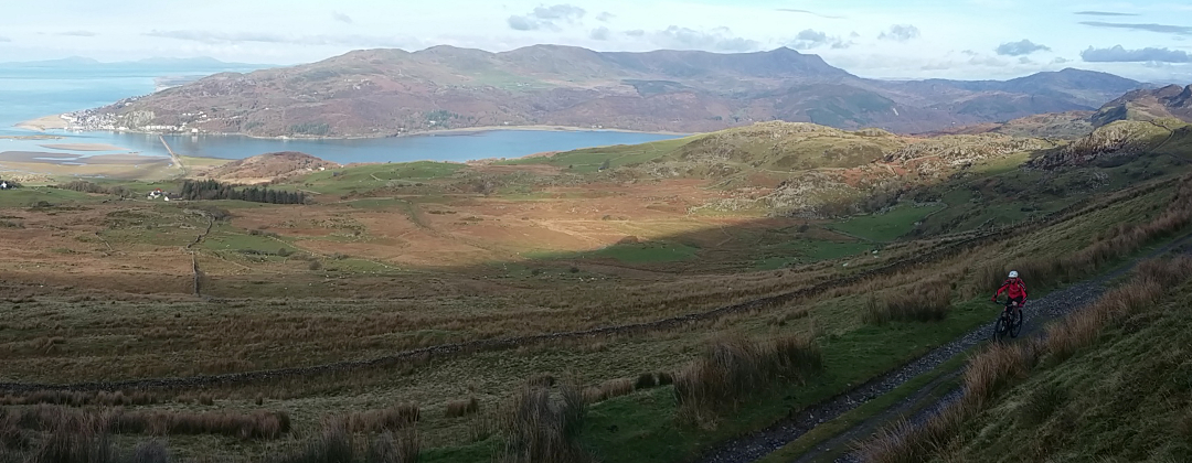
Llyn Cowlyd
North Wales Mountain Bike Route Guide
Region:
Snowdonia, North Wales
Difficulty:
Difficult
(Requires advanced skills and fitness)
Distance:
16.6 miles
Map:
OS Landranger 115
Route Text Download:
Llyn Cowlyd
GPS Download:
GPX and KML
(available via the full MapMyRide page for this route, on the right hand side of the page)
ViewRanger
Llyn Cowlyd Route
Back to North Wales
Route Guides
This mountain bike route of 16.6 miles, starting in Capel Curig, takes in the high lakes of Llyn Cowlyd and Llyn Crafnant. Although not a long ride it can take a while to complete with a good few miles of technical, rocky riding along the edge of Llyn Cowlyd and on the return from Llyn Crafnant. You may also need to stop a few times to take in the stunning scenery of the Snowdonia National Park.
1. Start from the car park behind Joe Brown’s and the Pinnacle shop and café in Capel Curig (GR720582). Turn right out of the car park and climb to a gated junction. Go through the gate then head straight on along the double track for a gradual climb of a few miles up the left hand side of the valley. The track eventually comes to a gate that leads into a campsite. Go straight on through the gate and then the campsite to a junction by a house on the left. Turn right and follow the lane a short way to a junction with the main road (GR673605).
2. Turn right and descend the road for ½ mile through a gentle left then right hand bend to a junction with a rocky double track on the left (GR691602). Turn left and climb the double track to a gate just before a house and barn. After the gate follow the track left then just before the house bear left, onto the grass, and climb steeply following the bridleway marker posts. The trail soon bears right through the tall grass and on to a very small bridge. Turn left directly after the bridge and climb steeply to a gate in the top left hand corner of the field (GR697605).
3. After the gate turn right and push up a very short climb before following the muddy criss-crossing singletrack in the direction of the wall on the right. At a vague junction, not long after passing a building on the right, bear right to follow the wall and descend to a junction with a double track. Go straight across the double track and descend to a gate at a stone bridge a short distance later (GR702604).
4. Go through the gate then over the rock slab bridge to cross the stream. Directly after the bridge turn sharp left, on the less obvious trail, to follow the line of the stream on the left. The trail is then very boggy for a while but with a scattering of boulders that act as stepping stones. Eventually the trail bears right away from the stream and the ground firms up. At a junction with a rocky track turn left. The rocks soon give way to a straight, grassy climb that is a push in the wet and a difficult ride in the dry. Follow it all the way up to a gated junction at the top, by a leat (GR711608).
5. After the gate turn right and follow the leat, on the left, going through a number of gates on the way. Continue along the trail until it comes to an end at a junction just after a small bridge in a dip (GR716609). Turn left and cross the bridge over the leat then go through a gate to a boggy plateau in a saddle between the peaks, with a great view down the Llyn Cowlyd valley on the right.
6. Go straight on from the gate along a vague grassy singletrack across the top of the plateau. The trail soon bears right through the marsh grass to a tricky section of rocky singletrack on the other side. Follow this trail as it descends towards the head of Llyn Cowlyd. The track then comes to a grassy area where it bears left for more rocky riding. After a while the track drops down a short technical descent to a stream crossing in a dip. At the junction just after bear left and push up a short, steep grassy climb. At the top get ready for a very technical descent, with some big drops, that ends at another stream crossing (GR719615).
7. Go across the stream then up a short climb on the boulder covered track to start the fun, technical trail along the left hand edge of Llyn Cowlyd. About 2/3rds of the way along the valley the trail comes to a junction with a thin track going straight on and a steep, rocky climb on the left (GR727627). Climb the track on the left to some large boulders, where it flattens off. After the boulders descend the trail back to the side of the reservoir then continue following the edge of the water to a gate. After the gate follow the double track to a junction on the left hand side of the dam (GR736635).
8. Turn left and climb steeply through a few bends on the loose rocky double track to a junction at the top. Turn right and follow the double track along the top of the hill. After a while the track descends through a couple of gates to a derelict building. Go straight on past the building to a junction underneath the large pipeline (GR743642). Turn right and descend to a crossroad junction then go straight on to a gate (GR744641).
9. Go through the gate and climb the lane to the top of the hill. Continue straight on over the cattle grid at the top then descend the lane into the Conwy Valley. Be careful as this steep lane is fast, covered in patches of loose gravel and has a number of steep hairpin corners which can be quite slippery. Go straight on past all of the junctions on the way down to where it ends at a junction, just after the cemetery, on the outskirts of Trefriw (GR779632).
10. Turn right and climb to the next junction. Go straight on and climb the lane for a couple of miles all the way to the Crafnant car park just before Llyn Crafnant (GR756618). Continue straight on along the lane and head up the valley, keeping Llyn Crafnant on the right. After passing Llyn Crafnant café (check they are open if you are planning to stop) the lane eventually descends to a gated junction at the far end of the lake (GR740602).
11. After the gate bear right then take the left hand track, a double track that climbs to a house. Directly at the far side of the house follow the track left. Keep going left around the house then go straight on through the car park area at the back, into a field. Go straight on across the field to a gate on the opposite side (GR739601). After the gate turn right and climb the steep grassy track. After a while climb through a number of steep, rocky and rutted bends. The track then flattens of before bearing right for a final bouldery push to the top, in a saddle on the ridge (GR738597).
12. Follow the trail straight on for a rocky, technical descent. After a while the trail bears left and comes to a gate just after a ford. After the gate follow the trail over a short climb, before it bears slightly right for a technical, rocky trail that descends very gently down the left hand side of the valley. Go through the next gate and up a short, tricky climb to a boggy plateau. Go straight on across the plateau then descend to a small stone bridge that crosses a stream on the right (GR731581).
13. Turn right over the bridge then follow the boulder paved trail that follows the line of the fence on the left. The trail eventually comes to two gates ahead (GR728581). Go through the right hand gate and follow the trail into the trees. Go up two short climbs in the woods, the second of which is unrideable rocky steps. At the far side of the woods go through a gate and follow the boulder paved track to a stream crossing in the far left hand corner of the field. Go left across the stream and through a gap in the dry stone wall then bear right and descend the muddy double track. Bear left around the hill and descend to a gated junction with the main road in Capel Curig (GR721581). Go straight ahead across the triangular junction, towards the Pinnacle shop and café, then continue straight on along the lane directly to the left of the shop. Follow the lane past Joe Brown’s then over the bridge for a short climb to the entrance of the car park on the right to complete the ride.