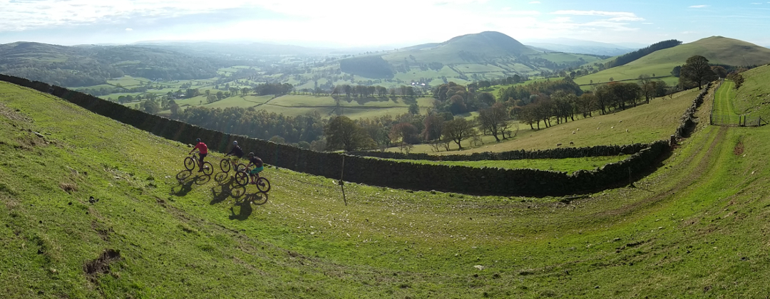
Moel Y Parc
North Wales Mountain Bike Route Guide
Region:
Clwydian Range, North Wales
Difficulty:
Moderate
(For Experienced Riders)
Distance:
9 miles
Map:
OS Landranger 125
Route Text Download:
Moel Y Parc
GPS Download:
GPX and KML
(available via the full MapMyRide page for this route, on the right hand side of the page)
ViewRanger
Moel Y Parc Route
Back to North Wales
Route Guides
This mountain bike route of 9 miles starts in Llangwynfan Forest at the southern end of Penycloddiau on the Clwydian Range. It is a route of double tracks, both grassy and rocky, with some steep climbs and descents to test your strength and skills. This route is best left to when it’s dry but still rideable in the wet despite a few muddy sections and the grassy trails being heavy going. The whole way round there are stunning views across North Wales, all the way to Snowdonia.
1. Start from the car park at the top of Llangwyfan Forest on the ridge of the Clwydian Range (GR138668). Take the second gate from the right at the back of the car park leading into the trees. Descend gently on the hardpack singletrack through the trees. After an open section, where the trail bears left, the track re-enters the trees for a twisty, muddy and rooty section. The descent ends at a small gate. Go through the gate and follow the track a short distance to a junction with a double track (GR126663).
2. Turn right and climb the double track for about 2 miles across the flank of the hill below Penycloddiau Fort. There are a number of gates on this climb, but they are well spaced and don’t interrupt the ride. About 3/4 of the way up the climb the track comes to a junction with a track on the left (GR121680). Go straight on and climb the track that soon bears left to a gate. After the gate continue climbing the track towards the transmitter mast on the ridge. At the top of the climb the track ends at a gated junction beneath the mast (GR121689).
3. After the gate go straight ahead a short distance to a junction with a gated track on the left. Turn left through the gate then descend the grassy double track that soon becomes steep and rocky. Continue descending through a couple of gates until the track ends at a junction in a dip by a house on the left. Go straight on up a short and steep climb to a three-way bridleway junction (GR113691).
4. Turn left and descend the grassy double track. Continue following the track ahead, going past a couple of tracks on the left, and bear gradually right around the hill. Eventually the track comes to a forked junction (GR107693). Take the right hand track and climb to a gate at the trees. Go through the gate then follow the track through the woods to a junction with a track on the right just before the track ahead descends (GR107697).
5. Turn right and climb the steep double track to a gate. After the gate continue climbing steeply ahead. After some time the track bears left through a wet, muddy patch before leaving the cover of the trees to climb steeply across the hillside. Eventually the track goes through a right hand bend before a final steep, grassy haul to a crossroad junction at the top (GR115697). Go straight across the junction and descend the grassy double track that initially bears left before turning right around the hill. At the trees the track becomes rocky and descends to a junction. Turn left and descend the rocky double track to the previously visited bridleway junction (GR113691).
6. Turn right and descend the grassy double track to a junction with the second grassy double track on the left, at the marker post (GR110690). Turn sharp left and descend the steep track ahead to the gate at the trees. Go through the gate and continue descending to a stream crossing at the bottom. Go through the stream then bear left and follow the muddy track by the steam. The track soon bears right and climbs steeply to a junction with a lane. Bear right to the next junction immediately after (GR113688).
7. Turn left and climb the lane between the hedges. After a while the lane turns left to a junction (GR117686). Turn right then go past a house on the left before climbing steeply through the trees. At the top the lane flattens off before coming to a three-way junction. Turn left then climb the steep, broken tarmac lane to where it ends at the previously visited T-junction (GR121680).
8. Turn right and follow the previously ridden double track. The track starts out flat, with stunning views across the Vale of Clwyd and Snowdonia on the right. After some time the track turns right through a small ford before descending to the previously visited junction, with a gate ahead (GR126663). Go straight on through the gate then descend, bearing left, to a junction with a lane at the bottom (GR130664).
9. Go straight ahead to the next junction, a short distance later, with a forest track ahead and where the lane turns right over a bridge (GR131664). Go straight ahead and climb the forest track through Llangwyfan Forest. After a while the forest track climbs through a right then left hand bend before returning to the car park at the top to complete the ride.

