
The Marin Cowlyd Killer
North Wales Mountain Bike Route Guide
Region:
Snowdonia, North Wales
Difficulty:
Difficult
(Requires advanced skills and fittness)
Distance:
26 miles
Map:
OS Landranger 115
Route Text Download:
The Marin – Cowlyd Killer
GPS Download:
GPX and KML
(available via the full MapMyRide page for this route, on the right hand side of the page)
ViewRanger
The Marin - Cowlyd Killer
Back to North Wales
Route Guides
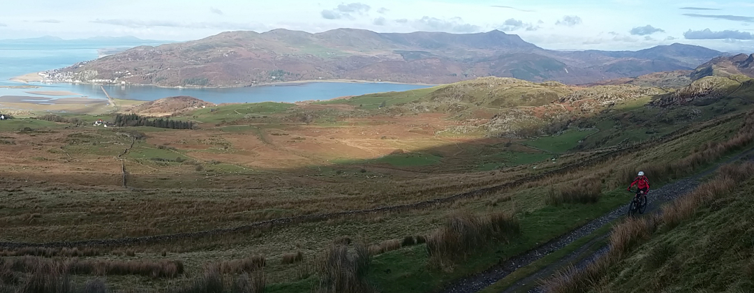
This mountain bike route of 26.3 miles adds an extremely challenging loop of trails to the Marin Trail. The extra riding starts with a long and very steep climb out of Trefriw before some very technical riding around Llyn Cowlyd. There is more technical riding from Capel Curig to Llyn Crafnant, before the route heads east, past Llyn Geirionydd, to join the Marin Trail. A lot of the technical riding is on the flat or uphill, which will reduce a good riders pace to around 4mph. It’s a real test of skill and slow control and you’ve got to like technical climbing.
1. The ride starts from the car park at the start of the Marin Trail (GR790609). Leave the car park by the main exit, which comes to a junction with a lane. Turn right and descend the lane to a junction with the road at the bottom (GR793611). Turn left, then left again at the junction with the road immediately after. Follow this road up the left hand side of the Conwy Valley to Trefriw. At the junction directly after the bridge in Trefriw, by the pub, turn left for a very steep tarmac climb between the houses (GR780631).
2. Climb straight across the crossroad junction to the next junction, with the cemetery signed off to the right (GR777633). Turn right and climb steeply past the cemetery, on the left. Continue climbing through a number of bends to a junction with a lane on the right, just after a left hand bend (GR773639). Go straight on and continue climbing steeply though a number of hairpin bends. Eventually the gradient reduces slightly before reaching the top of the climb, 2.5miles from Trefriw, at a cattle grid. Continue following the lane over the crest and descend to a gate (GR744642).
3. Go through the gate and follow the gravel track to the crossroad junction immediately after. Go straight on and climb to a junction underneath the pipeline (GR743642). Turn left and climb past a derelict house to a gate. After the gate climb the grassy double track, which gives increasingly good views up the Llyn Cowlyd valley. At the top follow the often wet double track to a junction, then bear left and descend the rocky track to the dam (GR736635).
4. Turn right and follow the double track along edge of the reservoir. After the next gate the trail becomes quite boggy in places. This soon gives way to an increasingly rocky and technical track that clings to the side of the valley, just above the reservoir. The riding is very challenging and it is extremely difficult to clean. At the head of the valley the trail descends to a small stream crossing. After the stream go up a short rocky push then drop down to another stream crossing. Push a short way up the next climb then remount and ride the singletrack to the boggy saddle between Pen Llithrig y Wrach and Craigiau Gleision. When the track comes to the open boggy area, near the top of the waterfall, bear right along the thin rocky singletrack. The singletrack skirts around the bog and soon bears left to a gate and a small bridge where the drainage ditches converge (GR716609).
5. Go over the bridge and follow the rocky and muddy trail straight ahead. After a while follow the trail right over a small bridge. After the bridge bear left and descend the a wide grassy track into the valley. This track can be quite boggy in places and crosses a few drainage ditches, using some small wooden bridges. While there is a marker post on the way down the track is fairly well defined. Eventually the track bears left to a gate. Go through the gate then at the forked junction take the left hand track that soon comes to some unrideable rocks. Go down the rocks then follow the track to a junction at a house. Continue straight on down the grassy track but be careful of the second unrideable rocky drop. After the rocks continue down the grassy track to a gated junction with the A5 (GR718589).
6. Turn left and follow the A5 into Capel Curig. The road bears right to a junction in Capel Curig by a line of shops on the right (GR721582). It is possible to buy food here. Turn left through the gate just before the chapel and climb the grassy double track that bears right around the hill to a drystone wall. Turn left through the gap in the wall then bear right on the rocks across the stream to the top of the climb. Follow the flagstones across the saddle between the peaks to a gate at the woods. Go through the gate for a tricky bit of singletrack that goes down a couple of short, stepped descents. After the woods continue straight on, following the fence on the right to a gate. After the gate go straight ahead along the increasingly technical trail. Keep going straight on along this trail to a bridge across a stream (GR732258).
7. After the bridge turn left and climb the grassy, rutted track to a boggy, grassy plateau at the top. Go straight on and descend the rocky trail to a gate a short distance later. Go straight on through the gate and follow the rocky trail that heads up the right hand side of the valley. This trail is another test of your technical riding ability. Near the head of the valley the trail bears left then drops through a stream crossing to a gate. Go through the gate and bear right on a steep and very rocky trail. It is possible to clean a lot of the climb but you have to be very good at technical climbing. At the top of the climb the trial comes to a junction in a saddle between the peaks (GR738597).
8. Go straight on, past the footpath on the right, for a steep technical descent. The boulders give way to rutted grass when the trail bears left and drops into the head of the next valley. Descend through a number of bends before finally turning right for a fast grassy finish to a gate in the drystone wall on the left. Turn left through the gate and ride across a field towards the house. Go past the left hand side of the house then bear right, around the back of the house, and descend the gravel track to a junction (GR740603).
9. Go across the junction and bear slightly left through the gate ahead. After the gate and follow the lane along the right hand side of Llyn Crafnant. Go past the café halfway down the lake. At the end of Llyn Crafnant continue along the lane to a junction with a wide forest track on the right, next to a car park on the left (GR717618). Turn right and climb the track into the forest. A short distance later follow the track right around a hairpin then climb for some time through the forest, to a junction with a track on the left, near the top (GR754607). Continue straight on over the crest of the climb then descend through a few bends to a junction on a left hand bend. Turn right and continue descending to the next junction on a long left hand bend (GR755602). Continue around the left hand bend then descend through a few more bends. At a junction with the double track on the right bear left and descend to the junction at the bottom near Llyn Geirionydd. Go past the track to the house on the left, then turn right and follow the straight track past the end of the lake, to a junction with a lane (GR761603).
10. Turn right, then at the next junction turn left and follow the lane up a short, sharp climb. The climb soon settles down into a long gradual gradient. Continue along this lane over the top of the hill then descend to where the lane ends at a T-junction (GR771588). Turn right to join the Marin Trail and follow the lane to the next junction with a forest track climbing off to the right, a short distance later (GR769587). Turn right and follow the Marin Trail signs all the way back to the main car park at the end of the trail to complete the ride.