
Derbyshire Dales and the High Peak Trail
Peak District Mountain Bike Route Guide
Region:
Derbyshire Dales, The White Peak
Difficulty:
Difficult
(Requires advanced skills and fittness)
Distance:
26 miles
Map:
OS Landranger 119
Route Text Download:
Derbyshire Dales and the High Peak Trail
GPS Download:
GPX and KML
(available via the full MapMyRide page for this route, on the right hand side of the page)
ViewRanger
Derbyshire Dales and the High Peak Trail Route
Back to Peak District
Route Guides
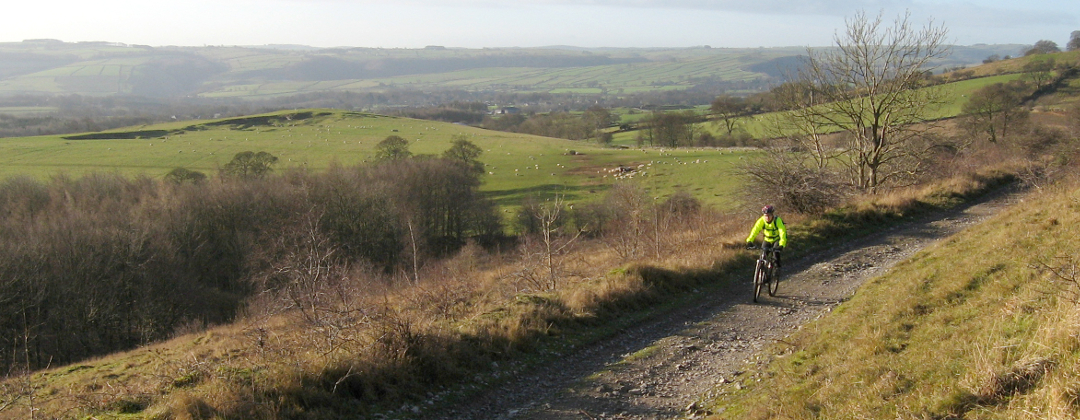
This mountain bike route of 26 miles is set in the Derbyshire Dales, an area of rolling hills and deep valleys in the Peak District. It travels in an anticlockwise direction from the High Peak Trail and takes in a good number of the Dales. As well as stunning scenery there are some great descents and hard climbs. Keep an eye on the weather though, if it’s wet it’ll be slippery with mud and the famous White Peak limestone. There is also one section, mentioned in the text, which could flood when the River Wye is high. It hasn't been a problem for me so far though (and there is an alternative route).
1. The ride starts in Sparklow car park on the High Peak Trail, just off the A515, 6.5 miles south east of Buxton (GR128659). Leave the car park using the exit to the road. Turn right and climb the road to where it ends at a junction with the A515. Turn left onto the A515 and climb the road to the next junction, with a track on the right between two buildings. Turn right and descend gently ahead, first going past a farm then between the stone walls, until it comes to a crossroad junction. Go straight across the junction and follow the track as it bears right then descends to a junction with a lane just after some cottages on the left (GR149670).
2. Turn left and follow the lane ahead. At the next junction, with a lane on the left sign posted to Flagg, go straight on and continue to where the lane ends at a junction (GR147687). Turn right and climb the lane to a crossroad junction a short distance later. Turn right and climb the lane to a staggered four-way junction at the top with a double track trail on either side (GR158685).
3. Turn left and descend the double track to a gate on the right in the bottom of the dip. Go right, through the gate, and descend the grassy trail along the dry stone wall on the right. Keep following the trail ahead until it comes to a small gate in a dry stone wall (GR160691). Go through the gate then turn left to start the Deep Dale descent. The muddy and rocky track heads straight down the dale in the direction of the wall on the left. With off camber sections and slippery limestone the descent needs skill and balance to negotiate successfully. If it’s wet the stream can join the trail at points making it even more difficult. Near the bottom of Deep Dale follow the track right up a short climb between the bushes before descending through a tight left hand bend that becomes rocky before reaching a stream (in the wet), with a fence straight ahead. Turn right and follow the rocky course of the stream, keeping to the right. The track then emerges from the trees into a field. Bear right and follow the vague trail diagonally across the field to a small gate in the opposite right hand corner (GR171703).
4. Go through the gate then turn left and follow the A6 up Taddington Dale. Climb the main road through a number of bends to a junction with a lane on the right, signed to Brushfield, on a left hand bend just after a layby on the left (GR157714). Be careful here as the A6 is pretty busy and there is not much visibility around the bend. Turn right and climb the lane. Go around a right hand hairpin and then continue climbing through a left hand bend to a gated junction at the first row of cottages of Brushfield (GR159715).
5. Bear right through the gate then go past the front of the cottages to a gate on the opposite side. Go straight on through the gate then follow the double track as it climbs right then left to another gate. After this gate continue climbing straight on to entrances into two fields ahead. Go into the left hand field and continue straight on over the grass, following the dry stone wall on the right. At the far side of the field the track comes to a gate (GR169716). Bear slightly right through the gate then bear left and follow the double track along the ridge, with views over Monsal Dale on the right. After the track emerges from the bushes bear left then right for a fast, loose and rocky descent. Descend to the next junction, in the bushes and trees where the main track turns 90deg left. Turn left and continue descending the double track, which soon comes to a gate. After the gate the track steepens up again for more loose and rocky descending. At the junction with the Monsal Trail continue descending ahead to go under the bridge. The track then bears left to a bridge over the River Wye at the bottom. Turn right and cross the bridge to a junction with a lane in Upperdale (GR177721).
6. Turn left and follow the road through Monsal Dale to Cressbrook. At the junction just after Cressbrook Mill, where the road turns right, climb the very steep lane ahead (GR173729). The lane bears left and continues climbing very steeply for some time to a crossroad junction. Go straight across and continue climbing steeply to the next junction. Go straight on then bear right and climb up a gentle slope to a junction by a church on the right (GR167733). Take the track on the left and descend, with a dry stone wall on the right, to a gate. After the gate follow the grassy track straight on to the next gate. After the gate turn 90deg left then descend through right then left hairpins before coming to a gate at the back of some houses. Go through the gate then descend on to the lane in Litton Mill in the bottom of the Miller’s Dale (GR160730).
7. Turn right and follow the lane for just under 2 miles through the stunning scenery of Miller’s Dale, to where it ends at a junction with the main road in the village (GR141734). Turn right and follow the main road to the next junction almost immediately after. Turn left and climb the very steep lane to a junction with a track on the left signposted as the Limestone Way (GR142734). Turn sharp left then climb the track as it bears right to a farm. Go straight ahead into the farm then at the far side of the yard turn left to a gate. Go through the gate then climb the double track to a junction with a track on the left. Follow the double track ahead that soon bears turns right and continues climbing. Continue climbing the track ahead for some time until it reaches a gated junction at the top (GR138745). After the gate turn left and follow the double track to where it ends at a crossroad junction by a house (GR137752).
8. Turn left and descend the lane through Monk’s Dale. Bear left then right through the dip at the bottom then climb a short way up the lane to a gated junction with a track on the left, signposted for the Pennine Bridleway (GR129752). Turn left through the gate then climb straight ahead diagonally across the field. At the wall on the opposite side of the field turn right and continue climbing to a gate. After the gate climb the muddy and rocky singletrack between the dry stone walls. At a junction near the top go ahead, then bear right to follow the track between the walls. The track goes through a couple of bends before coming to a gate. After the gate descend the track until it ends at a junction with a road in the village of Wormhill (GR122745).
9. Turn right onto the road then almost immediately left into Old Hall Farm. Climb the concrete track straight on through the farm to a gate at the top. Go through the gate then descend the grassy double track ahead, which can be very muddy in the wet. Follow the stone wall on the right to the next gate. After the gate continue ahead until there is the choice of two fields ahead. Enter the field on the right and continue straight on, following the dry stone wall now on the left, to a gate in the bottom corner of the field. Go through the gate and follow the double track to where it ends at a lane at the houses (GR111746).
10. Turn left and follow the lane past the houses. Stay on the lane and go past the tracks leading into the trees on the right. Ignore the Pennine bridleway track at this point, as it goes in the same direction is very soft and covered in deep hoof prints. The lane eventually bears right through a farm. A short distance after the farm the lane comes to a junction, on right hand bend, with a gated grassy track on the left (GR114729). Turn left through the gate then descend the steep, grassy track through a number of tight corners into Chee Dale. Near the bottom of the descent the track comes to a junction with a track on the right, which crosses a bridge, sign posted for the Pennine Bridleway (GR115727).
11. Go straight on and descend the singletrack that soon turns right under a bridge to the banks of the River Wye at the bottom. This is the section that can occasionally flood when the river is high, if so climb back to the Pennine Bridleway, go across the bridge then turn right on the Monsal Trail and follow it to Blackwell Mill Cycle Hire. Go straight on and follow the river to the bridge at the Blackwell Mill cottages. Go left over the wooden bridge. At the junction on the opposite side bear right to Blackwell Mill cycle hire and café, a good place for refreshment and bike repairs. After the café follow the dirt lane as it winds through Wye Dale, with the river now on the right, going under the railway bridges. At the end of the trail go through the car park to a junction with the A6 (GR103724).
12. Turn right onto the A6 and follow it for roughly ½ mile to a junction, on a left hand bend in the trees, with a lane on the right leading across a bridge to a cottage. Go straight on along the main road to a junction with a muddy double track on the left directly after (GR094725). Be careful at this junction as it is on a blind bend of a busy main road. If you go under a second railway bridge on the A6 you have gone too far. Turn sharp left then climb the track to a bridge. Bear right and cross the bridge over the railway. On the opposite side bear left and climb the steep, loose track to King Sterndale at the top. At the village go straight ahead and follow the lane, between the fields, to a junction with a dirt track where the lane turns right (GR092715).
13. Go straight on and follow the dirt track to a gate. After the gate go straight ahead and cross the field diagonally to a gate in the dry stone wall on the other side. Go through the gate and head in the same direction to cut diagonally across this second field towards the power lines and a small gate in the dry stone wall ahead. After the small gate follow the grassy singletrack along the edge of Deep Dale (a different one) on the left. The track soon descends into Deep Dale, where it becomes rocky. At the bottom turn left to a gate at the junction of Deep Dale, Back Dale and Horseshoe Dale (GR096707). Go through the gate then turn left on the grassy track then right to gently climb the wide grassy track along the bottom of Horseshoe Dale. There are little rock sections on the way up to keep things interesting. Near the end the track comes to a small gate ahead at a farm. Go straight on through the gate then at the far side of the buildings turn left and climb a short way to the road (GR098698).
14. Continue straight ahead along the road and climb to a junction on a left hand bend at the top (GR102699). Go straight on to leave the main road and head towards Chelmorton. At the following crossroad junction go straight on. After a while the road climbs left then right, past a lane on the left, to a four-way junction at the top (GR119697). Turn right and climb the double track. The track soon flattens off and undulates across the top of the hill to a junction with a lane, after roughly 1 mile. Turn left and follow the lane to a junction at the A515 (GR113676).
15. Go across the main road then turn right and follow the Pennine Bridleway to the left of the fence. At the junction a short distance later turn left and descend the wide trail to a junction in the bottom of the dip (GR110673). Turn left through the gate then follow the High Peak Trail for 1.5 miles on a gentle downhill spin all the way back to the Sparklow car park to complete the ride.