
Gunnerside and Apedale
Yorkshire Mountain Bike Route Guide
Region:
Swaledale, The Yorkshire Dales
Difficulty:
Difficult
(Requires advanced skills and fittness)
Distance:
31 miles
Map:
OS Explorer OL30
Route Text Download:
Gunnerside and Apedale
GPS Download:
GPX and KML
(available via the full MapMyRide page for this route, on the right hand side of the page)
Back to Yorkshire
Route Guides
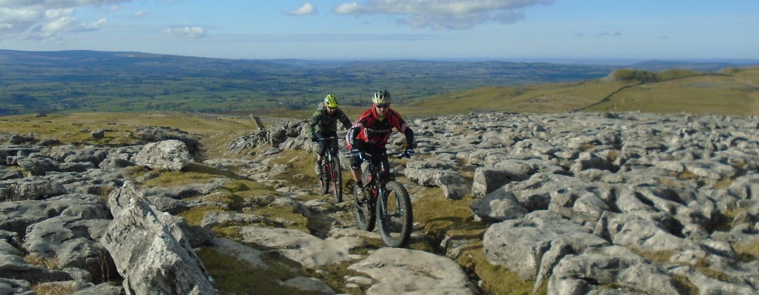
This mountain bike route of 31 miles starts from the Dales Bike Centre in Swaledale. It heads up the valley to ride the trails of around Gunnerside before returning through Apedale. It’s a proper, big XC route with trails that are mainly rocky double track and grassy double track. There are also sections of singletrack and technical rocky riding to spice things up. The climbs are big and the views stunning, but also bleak at times as the route travels through the areas mining history. Although a long, hard ride Gunnerside has some good mid-ride refuelling options.
1. Leave the Dales Bikes Centre (GR046987) and turn right onto the main road. Go across the bridge to the junction directly after The Bridge Inn in Grinton, where the main road turns left (GR046984). Go straight on and climb the steep lane ahead out of Grinton. Climb the lane for some time to a junction by a dirt car park on the right. Turn right and climb the steep lane to a junction with a rocky double track on the right, where the lane turns left (GR044974).
2. Turn right and follow the track up a gentle climb. After a while the track begins to descend gently. A little before the double track descends to a gate, in the dip ahead, take the singletrack through the heather on the right and descend to a rocky stream crossing (GR039972). After the stream climb the track on the other side and go straight on over the crest then descend a short way to a gate. At the junction directly after the gate turn left and descend the grassy singletrack parallel to the fence on the left. The descent finishes at a junction with a grassy track. Turn left to a gate (GR309977).
3. Go through the gate and follow the grassy track up a short climb, keeping to the drystone wall on the right. The soon trail flattens off and contours the hillside. When the drystone wall drops away on the right continue straight on, staying high on the now rocky trail. The drystone wall soon comes back up to meet the trail. At the end of the wall turn right at the vague junction and drop diagonally to a rocky double track that descends to a gate. Go through the gate and descend left then right to the next gate. After this gate descend to a junction with a lane (GR032982).
4. Turn left on the lane and descend all the way to a junction at the bottom with a lane going over a stone bridge on the right. Go straight on, keeping the river on the right. At the next group of houses, where the lane kicks up to the left, turn right on the gravel track that continues following the river (GR003982). Follow the track along the valley to the farm at the far end. Go straight on through the farm then follow the lane to the next junction with the lane across a bridge on the right (GR977973).
5. Go straight on and follow the lane to a junction with a track on the right where the lane turns left, just before a large house (GR975972). Turn right and follow the hardpack track to a ford a short distance later. Go through the ford then follow the track ahead up the valley. Continue along the track to where it ends at a junction at a cattle grid, with the main road ahead (GR949977). Turn right and descend the main road across a stone bridge then into Gunnerside. Continue along the road to a junction in the middle of Gunnerside, where the main road turns square right (GR951982).
6. Turn left and climb the lane out of the village and across the side of the valley. Climb past the houses of Dyke Heads on the left to a junction with a rocky double track on the right, next to Dyke Heads farm (GR941983). Turn right and climb the track, which soon bears left to climb steadily up the left hand side of valley above Gunnerside Beck. About two thirds of the way up the track bears left and descends through a gate before turning right over a stream and climbing to a junction on the following left hand bend (GR935006). Take the grassy track on the right and climb to the next junction a short distance later. Turn right again for a flat section of track that can be a bit boggy. The track soon bears left for a fast rocky descent the ends at some derelict buildings and mine workings at a junction of two streams (GR936017).
7. Go straight on through the water of Blind Gill then, on the other side, turn right and go across the small stone bridge over Blakethwaite Gill. Directly after the bridge follow the thin, grassy track down the left hand side of the derelict building and go past a steep track that climbs out of the valley on the left. Follow the rock strewn track ahead, staying beside Gunnerside Beck on the right. After a while take the rocky singletrack on the left that climbs steeply out of the valley. At the junction on the way up continue ahead, climbing steeply to a signposted crossroad below a rock filled gulley (GR940012).
8. Turn right and follow the rocky track that descends down the valley past the derelict buildings. After a stream crossing the track comes to a forked junction, marked by a big cairn (GR939008). Turn left and climb the singletrack, which has a few tricky sections on the way up. Continue straight on to where a track comes in from the left near the old kiln. At the following forked junction bear right along the grassy double track that leads to a gate in the middle of the drystone wall ahead (GR942002).
9. After the gate descend the fast, grassy track that ends with a couple of rocky bends leading to a farm. Climb to the junction at the farm buildings (GR947994).Turn left and follow the double track around the back of the buildings before climbing to a gate. After the gate follow the track as it undulates across the hill, eventually coming to a triangular junction (GR956988). Bear left and follow the rutted double track ahead, directly to the left of the drystone wall. Go past the grassy trails climbing off to the left and follow the track to where it ends at a double track T-junction directly after a small stream crossing (GR960986).
10. Go straight across the T-junction onto the boggy ground ahead. The track to follow here starts as a very, very vague bridleway that heads into the boggy grass (see detailed Barf End picture). With the stream at your back face the low ridge directly ahead that runs parallel to the dry stone wall, below on the right, then head in a roughly 11 o’clock direction on a very vague sheep trail across the grass. In a short distance climb onto the low ridge and go ahead through a boggy section, this is short and mainly wet moss and marsh grass. At the far side continue ahead, just to the left of the ridge, where a defined singletrack trail soon appears. Follow this increasingly rocky track that soon begins to descend. When the rocks give way to grass continue ahead to a gate in the drystone wall on the right (GR967985).
11. Go through the gate and follow the grassy double track directly away from the gate. Descend the track to where it ends at a wide gassy junction (GR971981). Turn right and follow a wide grassy track over a few sections of bedrock along a plateau in the direction of Swaledale, below on the left. Continue in the direction of the ridge on the left to a gate in a dry stone wall ahead. Go through the gate to a junction immediately after (GR963983). Turn left and drop off the ridge to descend a steep grassy track. As the track descends it goes through a rocky, sunken trail by a wall passing some houses on the left. After the houses continue descending the increasingly rocky track straight on to where it ends at a lane by a house. Bear left on the lane then go through a gate to a junction with the main road on the edge of Gunnerside (GR953982).
12. Go straight ahead and follow the road into Gunnerside. On the way in there are some cafes on the right. Go across the stream to the previously visited junction in the middle of the village (GR951982). Follow the main road left and descend out of the village then go across the bridge and climb to the following junction (GR949977). Turn left and cross the cattle grid then climb the lane on the right. Follow the lane past a farm before eventually climbing to a three-way junction at Crackpot (GR973966). Turn right and climb for a while more before a gentle descent to Summer Lodge. Go straight on through the gate at Summer Lodge for a very steep gravel climb. The first part is definitely the worst and will be a push for most. Eventually the track descends gently through a ford to a gate just after. Go through the gate and bear left for the final, steep but rideable haul to a junction with a lane at the top (GR964948).
13. Turn left and descend the lane. After passing a drystone wall on the left the road descends steeply before flattening off and coming to a staggered four-way junction above a farm house on the left (GR983964). Turn right and climb the rocky double track sign posted to Bolton Abbey. Climb past the junction with a track on the right and bear left to continue the ascent through the old mine works. At the next junction, with a track on the left, keep climbing straight on up the loose rocks. The track eventually levels off and comes to a square right then left kink to at the top. After the kink continue along the main trail right for the long descent into Apedale. The descent starts on gravel and drops steeply on loose rocks through some old mine works before continuing along a long section of fast, flat hardpack. Be careful on the steep top section as it's easy to carry too much speed into a couple of the corners. Follow the main track ahead down the dale to a wide dirt track crossroad (GR030942).
14. Turn left and climb the gravel double track. At the forked junction near the top follow the right hand track to the cairns at the summit of Greets Hill (GR028956). Go through the gate on the right for a tricky, rocky track that follows the fence on the left. The trail then steepens for a fast blast straight on down through the right hand side of some old mine workings. Continue following the track to where it ends at a junction with a lane. Turn left on the lane then descend to a junction on the following right hand bend with a singletrack bridleway on the left that heads into the heather (GR040967).
15. Turn left and descend the thin track through the heather to where it ends at a junction a rocky double track (GR040968). Turn left and follow the track along the line of the hill to a stone building. After the building bear right and descend the track to a four-way junction (GR033972). Take the first track on the right and descend the rutted grassy double track. The track becomes rocky before dropping through a few bends to a ford. After the ford climb left through a gate. Directly after the gate descend the singletrack on the left a short way to the previously visited stream crossing (GR039972).
16. Turn left through the stream then climb the track on the other side. Go straight on over the crest then descend a short way to a gate. At the junction directly after the gate turn left and descend the grassy singletrack parallel to the fence on the left. The descent finishes at a junction with a grassy track (GR309977). Turn right and follow the vague grassy singletrack to a vague forked junction, the right hand track of which heads directly in the direction of Grinton Lodge YHA. Follow the grassy track that bears slightly left and descend to where it ends at a junction with a more defined grassy track (GR042977). Turn left and descend to a gate. After the gate descend through the houses to where the track ends at a junction with a lane (GR045980). Turn left and descend the lane all the way to the junction at the Bridge Inn in Grinton. Go straight on and cross the bridge over the River Swale then complete the ride by returning to the Dales Bike Centre on the left.