
Ingleton and the Pennine Bridleway
Yorkshire Mountain Bike Route Guide
Region:
Ingleton, Yorkshire Dales
Difficulty:
Difficult
(Requires advanced skills and fitness)
Distance:
37 miles
Map:
OS Landranger 98
Route Text Download:
Ingleton and the Pennine Bridleway
GPS Download:
GPX and KML
(available via the full MapMyRide page for this route, on the right hand side of the page)
Back to Yorkshire
Route Guides
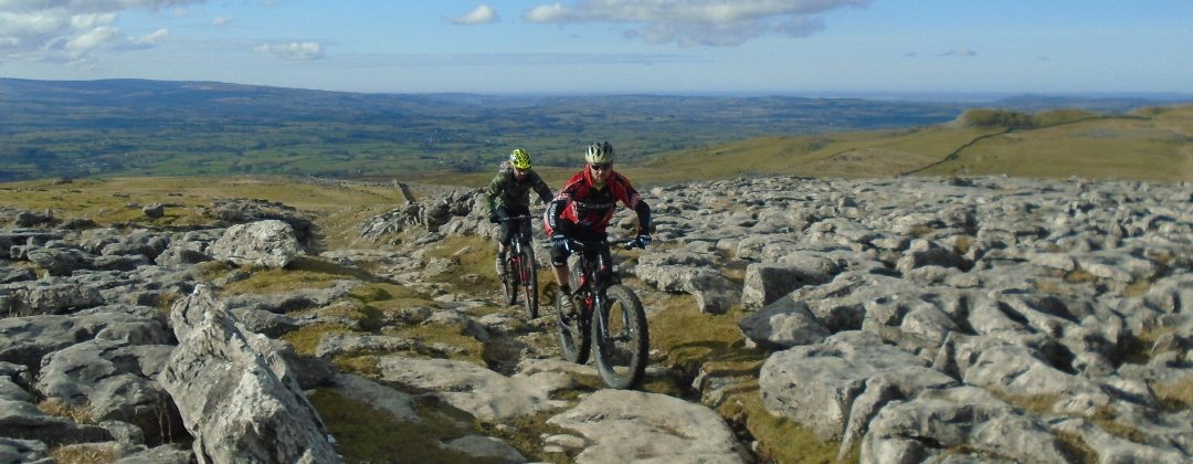
This is a mountain bike route of 37 miles that starts in Ingleton, on the western edge of the Yorkshire Dales. It is a ride across big moors with some great rocky descents and lots of limestone features to look at on the way. The first half of the route heads out around Whernside before returning on the Pennine Bridleway.
1. Start from the Information Centrecar park (GR694730) in the middle of Ingleton. Leave the car park, keeping the information centre on the right, and descend to the T-junction at the exit. Turn right and go under the bridge to the following junction (GR694731). Turn left and descend a short way to the next junction. Turn left and descend to a junction with a lane on the right directly after crossing the bridge at the bottom (GR694732). Turn right and follow the lane out of the houses for a steep climb through the trees. After a while the lane plateaus and goes down a gentle descent before climbing again to a gated junction on a right hand bend (GR699745).
2. Go through the gate on the left and climb the lane towards the Twisleton Hall farm. Go through the gate just before the farm then follow the lane through the buildings to where it turns left to another gate. After the gate follow the rocky double track for a short distance to a signposted junction with a bridleway on the right (GR700753). Turn right and climb the grassy track across the face of the hill. Follow the track through a right hand hairpin at the wall then climb the steep rocky section. At the top the track bears left to a grassy junction. Take the either track and go through a long left hand bend. Continue climbing the obvious track through the tricky rock sections to a grassy junction at the start of the plateau at the top (GR705760).
3. Go straight ahead across the moss and marsh grass on the track that heads just to the left of a large area of limestone pavement. In drier weather this track is easily rideable but in longer periods of wet weather it will be quite boggy in places. Then track then bears slightly right around the limestone pavement where it becomes grassy, firm and more defined. Follow this track up the valley along the lumpy, grassy plateau to a grassy junction in the next section of limestone pavement on the left (GR713768). Turn left and follow the grassy singletrack a short distance to a grassy crossroad junction in the limestone pavement. Turn right and follow the track for a short distance to vague junction directly at the edge of limestone pavement. Turn right then follow the grassy track that soon becomes defined and follows the blue topped marker posts, staying just below the grassy bank on the left. Keep following this track straight ahead for quite some time, as it descends gently to a junction with a track at a farm (GR731783).
4. Go straight on through the gate and follow the double track through the farm. On the far side of the farm descend the rocky double track through a number of corners. At a junction with a lane on the right go straight on to the next junction directly after (GR739790). Go straight on through the gate in the stone wall then follow the gravel singletrack through the field to the next farm. Go straight on through the farm then through a gate just to the right of the last barn. Go straight ahead through fields and gates to the next farm. Go straight on through the farm to a junction with a lane between the barns on the right (GR747797). Go straight ahead and follow the lane on the other side of the farm. Keep going straight on, past the tracks on either side, to a forked junction at Winterscales Farm (GR753801).
5. Bear right over the small hump back bridge to the rocky double track and gate on the other side. Go through the gate then follow the track left as it follows the line of the river on the left. After a while follow the track right and climb to the bridge under the railway to a junction directly on the other side (GR758803). Turn left and follow the wide rocky double track up the valley. As it’s on the Three Peaks route there can be quite a few walkers on this section. Stay on the main track as it goes up the valley, which crosses a few streams on the way before finally bearing left over a stone bridge, across the railway, to a gate (GR360819).
6. Go through the gate and climb the steep, stepped, rocky track. After a while the steps give way to a rideable but still difficult rocky climb that follows the line of the fence on the left. Go past the junction with a footpath on the left halfway up, to a gate at the top (GR755827). After the gate go straight on along the undulating grassy track. After a while the track turns right for an eroded grassy descent. At the derelict building follow the track left then along a flat section that crosses the side of the hill to a gate in the stone walls. Go straight on through this gate and all the rest for a long rocky descent into the valley. Directly after the last gate, in the trees, follow the track left to a junction with a lane (GR724857).
7. Turn right and descend the lane to the next junction a short distance later (GR722859). Turn right again and follow the lane past the entrance to Whernside Manor. Follow the lane for a few miles up the valley until it ends at a junction directly after a bridge at the church on the edge of Cowgill (GR755869). Turn right and follow the lane past a junction with a lane on the left to a three way junction at the old signpost in the village centre (GR760869). Turn left and climb the lane through the steep bends. Climb straight on over the railway at Dent Station then continue up the long climb. At the junction at the top turn right on the rocky double to join the Pennine Bridleway (GR780880).
8. Follow the double track across the side of the hill, high above the valley on the right. Eventually the track descends right to a four way junction in the saddle of the hills (GR792861). Follow the Pennine Bridleway markers left through the gate then immediately right. Descend a short way to the bottom of the dip then climb the rocky track along the line of the hill top. As it ascends the track becomes grassy. At the top the track bears slightly left before descending through a right hand bend into a wide sunken trail. Go through the gate at the far end and continue along the trail that soon becomes a fast rocky descent that ends at a junction with a lane (GR790835).
9. Turn right to leave the Pennine Bridleway then descend the lane a short distance to a junction with a bridleway on the left at the start of the next hill on the left (GR786836). Turn left and climb gently on the rocky singletrack in the direction of the crest of the hill on the right. Near the top the track continues straight ahead through a boggy section before reaching a wide rocky descent. The track descends to a junction at the corner of a stone wall (GR788817). Go straight ahead onto the grass and through the gate then descend, bearing right, keeping by the wall to a junction with a lane. Go straight on and descend the lane to a junction with the main road (GR789811).
10. Turn right and follow the main road for a short while to a junction with a wide gravel track on the left at the top of a short climb on a right hand bend (GR785803). Turn left onto the wide gravel track and descend to a gate. At the junction directly after the gate go left and descend to a bridge. After crossing the bridge climb the wide track for some time to the next junction at Cam End, signposted for the Pennine Bridleway (GR801804). Turn right onto the Pennine Bridleway and descend the rocky double track to bridge over a stream at the bottom. Go over the bridge and continue following the double track until it eventually comes to a gated three-way junction (GR804773). Turn right and descend the broken tarmac to a gate by a house at the bottom (GR800768).
11. Go through the gate then follow the undulating lane that includes a couple of short, steep climbs. Continue to a junction with a gated track on the right, at the top of one of these climbs, signposted for the Pennine Bridleway (GR801760). Go right through the gate then descend the winding gravel track to a grassy junction just before a barn at the bottom. Turn left and follow the grassy track to a gate. After the gate follow the gravel track that eventually descends to a wooden bridge over the River Ribble (GR796753). Go over the bridge then climb the grassy double track to a gated bridge under the railway. After going under the bridge climb the track right then left before coming to a junction at the road (GR787747).
12. Follow the Pennine Bridleway sign through a small gate on the left then descend a short way beside the road. At the end of the track turn right and cross the road to a junction with a lane on the other side. Go across the cattle grid and climb the lane to a junction (GR787746). Turn right and follow the lane to a junction with a grassy double track ahead, where the lane bears right to a farm (GR785746). Climb the double track ahead that eventually comes to a gate. Go through the gate then turn left through the next gate. After this second gate climb the grassy track straight on, following the Pennine Bridleway markers, to a cross road junction with a footpath (GR778735).
13. Go straight on and follow the track in the direction of the rocky edge on the right. The track eventually comes to a gate in a drystone wall at the top of the climb. Go through the gate then follow the track in the direction of the wall on the left while taking in the views across Moughton Scars. At the following grassy junction with the small pile of stones take the right hand track in the direction of the Pennine Bridleway marker (GR772725). At the following junction go straight on. At the next junction, directly after a short rocky section, follow the Pennine Bridleway marker right (GR767720). The track soon bears left to a junction. Go straight on, or right it doesn’t matter which, and descend to a gate. Go through the gate then descend the grassy track straight on through the field to a gate on the left (GR758716).
14. Follow the Pennine Bridleway marker through the gate and descend the loose, rocky double track between the walls. The track then flattens off for a bit as it passes Ingleborough Cave, below in the valley on the right, before steepening for another rocky plummet. Keep your speed up if you can to get up the following climb, by the trees on the right, before the track flattens off again and comes to a junction (GR751694). Turn right then take heed of the tunnel warning signs before descending the wide rocky track. The first tunnel, although short, is pitch black. After the second tunnel the track ends at a junction on the edge of Clapham (GR746694).
15. Turn right to another junction immediately after then go straight on past the church. Cross the river to a junction at the far side of the bridge. Turn right and climb to the entrance of the Ingleborough Cave trail, making sure to stop and look at the waterfall on the right and read about boy who went down them in the rowing boat. Follow the lane left then at the junction shortly after go straight on, past a line of houses on the left, to another junction shortly after (GR743695). Go straight ahead and follow cycle route 68 on lane along the bottom slopes of Ingleborough, on the right. The lane begins by climbing for a while, sometimes quite steeply. After reaching the top descend the lane straight on until it ends at a junction with the B6255 on the edge of Ingleton (GR700730). Turn left and descend the main road. Go past a junction with a road on the right then descend to the second car park on the right, signed for cycle route 68 (GR696729). Turn right into the car park to complete the ride back at the Information Centre.