
Ribblehead and Hawes
Yorkshire Dales Mountain Bike Route Guide
Region:
Ribblehead, Yorkshire Dales
Difficulty:
Difficult
(Requires advanced skills and fitness)
Distance:
29.9 miles
Map:
OS Landranger 98
Route Text Download:
Ribblehead and Hawes
GPS Download:
GPX and KML
(available via the full MapMyRide page for this route, on the right hand side of the page)
Back to Yorkshire
Route Guides
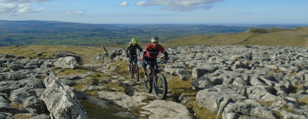
This mountain bike route of 29.9 miles starts from near the Ribblehead Viaduct on the western side of the Yorkshire Dales. It uses Cam High Road and the Pennine Way for a ride around Hawes and back. While mainly using double track there is a bit of everything with fast blasts, steep technical riding, some hard climbing and easy spins with stunning views. In wetter weather this can be a very big ride but with Hawes at the halfway point there are opportunities for refuelling and bike maintenance.
1. Start from the layby at the junction of the B6255 and B6479 just below The Station Inn, near the Ribblehead Viaduct (GR766792). Turn right from the layby and climb the B6255 away from the junction. After a while the road passes the Gearstones cottages and outdoor centre on the right. Continue following the road, which after a while goes around a right hand bend and through a dip. Climb out of the dip to a left hand bend at the top, with a junction to a gated track on the right (GR785803).
2. Turn right onto the gravel track and go through the gate then descend straight ahead to the bridge. Go over the bridge then climb the wide track for some time to the next junction at Cam End, signed with the Pennine Bridleway going right (GR801804). Continue straight on and climb the wide track to the next junction. Take the left hand fork to go through a gate and keep climbing. On the way up the track goes through another gate before reaching a junction, with a tarmac lane ahead. Go straight ahead on the lane along the top of the hill. After a while go across a cattle grid and keep following the lane to a junction with a track on the left just before the lane goes through a stone wall (GR829834).
3. Turn left and follow the double track of West Cam Road in the direction of the stone wall on the left. The track soon begins to generally descend along the top of the valley of Snaizeholme, below on the left. Navigation from here is simply a case of following the double track ahead for some miles as it descends into Wensleydale. After a while the track becomes steep and rocky with a long section of loose, technical boulders. After this the track levels off slightly and the boulders disappear for a fast finish to the descent. Near the end of the descent the track comes to a junction (GR857892). Go straight on and descend to where the track ends at a junction with the B6255 (GR859895).
4. Go straight on and descend the road a very short way to a gated bridleway on the left (GR860895). Go left through the gate and follow the soft grassy track ahead through the field. After going over the crest of a short climb follow the vague grassy track left and descend gently through the long, thin field with a stone wall above on the left and below on the right. After a while the track ends at a gated junction with a lane (GR852898). Go through the gate then turn right and follow the lane through a few bends before it starts descending. After the lane goes under a small viaduct it finishes at a junction with a road in Appersett in the bottom of the valley (GR857906).
5. Turn left and immediately follow the main road over a bridge. The road then turns right and goes over another bridge. Directly after that bridge the road turns sharp left before coming to a junction with a road on the right signed to Hardraw. Follow the main road straight on. After a while the road starts climbing then comes to a junction with the next lane on the right directly at the end of the woods, by a house on the left (GR842921).
6. Turn right over the cattle grid then follow the lane through a dip before going up a steep climb. After a while the lane flattens off a bit and heads up the left hand side of a valley. It then descends to some woods on the left. Stay on the lane as it climbs a short way then turns right at the top and descends to the small village of Cotterdale. Follow the lane right then left through the village to where it ends just after the last house. Continue ahead on the track by the stream and go past the metal bridge on the right to a smaller wooden one just after (GR832943).
7. Go right across the wooden bridge then right again on the far side to follow the singletrack into the trees. At the trees the track turns left to a gate. Go through the gate then up a steep climb following the stream on the right. On the way up go right across the small bridge then continue climbing by the stream to a junction with a wide gravel track (GR833943). Turn left and climb the wide gravel track, going past junctions with two access tracks on the left, to a three-way junction where the gravel track climbs through a right hand hairpin bend (GR834949). Follow the gravel track right and climb to the next hairpin bend and junction. Follow the gravel track left and continue climbing. Soon after the track turns right and comes to another junction. Go straight on and continue climbing to a junction just as the track emerges from the forest (GR836948).
8. Follow the muddy double track straight on to traverse the hillside in the direction of the valley below on the right. After going through a gap in a stone wall continue following the double track straight on. Eventually the track comes to a junction with the Pennine Way (GR847932). Turn right and descend a short way to a gate. Go through the gate then descend through a couple of long corners before a fast double track descent that eventually comes to a junction (GR857921). Turn right then go through a gate for more double track descending that eventually comes to an end at a junction with a road on the edge of Hardraw (GR866912).
9. Turn left and follow the road through Hardraw, going past the Green Dragon Inn in the middle. On the far side climb the lane out of the village to a road junction at the top then go straight on and descend to the next junction (GR876909). Turn right and descend the road in the direction of Hawes. It goes through a couple of bends by the river then after the second bridge enters Hawes. Keep going straight on to a junction with the main road, with the Dales Countryside Museum and Stage 1 Cycles on the left (GR874898).
10. Go straight across the first road then past a small car park on the right. At the junction with the next road, directly after the car park, turn right and climb into the centre of Hawes going over the bridge and past the waterfall on the way. At the junction on the end of the high street go straight ahead along the B6255 to the next junction with a road on the left, signed for the Wensleydale Creamery (GR870898). Turn left and climb the road past the Wensleydale Creamery to where it comes to a T-junction in Gayle (GR871892). Turn right and follow the lane ahead through the houses. On the far side of the houses the lane bears left and climbs to a junction (GR867891).
11. Turn right and climb to the next junction a short distance later. Turn left and climb to a junction with the second lane on the right signed for Gaudy House (GR865889). Turn right and go up the steep lane. At the top the lane flattens off and comes to a gated junction with a bridleway on the left by a stone barn on the right, just before reaching the house (GR860886). Go left through the gate and into the field then bear right and climb the vague track steeply through the field, keeping to the wall on the right. This bit is usually a push. Go straight on through the gate in the top right hand corner of the field (GR855884). Go straight on and follow the wall on the left through the next field, where it is possible to ride again. At the far side of the field bear slightly left through the wall on a well-defined bit of singletrack. The track then bears right and comes to a vague junction a short distance later. Bear left across the broken remains of a wall and follow the boggy singletrack to a gate just after the track turns left (GR852882).
12. Go through the gate then climb the steep, grassy track in the direction of the wall on the left. While this track is rideable there are a number of soft, boggy bits, especially in the wet, so you could be pushing again. Eventually the track comes to a forked junction but both directions bear left and come to a gate (GR849878). Go through the gate and follow the now more defined and rideable track, which is still boggy in places, keeping to the wall on the left. After a while the track kicks up a grassy slope and comes to a plateau. Follow the track right across the plateau, which ends at a wide boggy section, there is a dry line on the far left. Continue straight on across the bog to follow the grassy track up the next short climb. After reaching the first visible crest the track bears left and climbs to a gate (GR845872). Go through the gate then follow the flat grassy singletrack a short way to the next vague junction at a cairn. Follow the track ahead, directly to the right of the low remains of a wall, in the direction of the cairns. After a while the muddy singletrack descends to a junction with the top rocky part of the previously ridden West Cam Road (GR843869).
13. Turn left and climb the double track of West Cam Road all the way back to where it ends at the junction with the lane (GR829834). Turn right and follow the lane all the way to where it ends at the junction with the two dirt tracks (GR821827). Go straight on and descend the previously ridden track to the junction at the second gate. Go through the gate then descend straight on to the next junction (GR801804). Go straight on, past the Pennine Bridleway track to the left, and descend to the bridge at the bottom. After crossing the bridge climb the track to the next junction, with a gated track on the right (GR785803). Turn right and go through the gate to the junction with the B6255. Turn left and follow the road, mainly descending, all the way back to the layby at the junction of the B6255 and B6479 to complete the ride.