
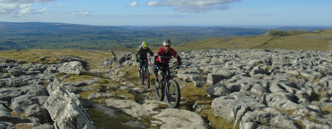
Settle and Malham Moor
Yorkshire Dales MTB Route Guide
Region:
Settle, Yorkshire Dales
Difficulty:
Difficult
(Requires advanced skills and fitness)
Distance:
27 miles
Map:
OS Landranger 98
Route Text Download:
Settle and Malham Moor
GPS Download:
GPX and KML
(available via the full MapMyRide page for this route, on the right hand side of the page)
ViewRanger
Settle and Malham Moor Route
Back to Yorkshire
Route Guides
This mountain bike route of 27 miles starts in Settle in the Yorkshire Dales. It’s a ride of long climbs and long descents on a mixture of grassy and limestone double track, which travels in a figure of eight around Malham. The route takes in Mastiles Lane, Stockdale Lane and lots of limestone pavement. While not generally that technical there are a few sections of limestone rocks on the last descent to keep you on your toes, especially when they are wet!
1. Start from Greenfoot car park in Settle, by the rugby pitch (GR820634). Exit the car park, keeping the rugby pitch on the right. From the car park follow the lane straight ahead to where it ends at a junction (GR819631). Turn left and follow the lane as it climbs around the edge of Settle, with the houses on the left. The lane enters the town where it flattens off and continues ahead to a three-way road junction (GR821634). Go straight on following the Pennine Bridleway sign. At the next junction, a short distance later, take the right hand fork on the lane signed as a dead end. At the next three junctions turn right. After the last right turn climb the thin lane that immediately bears left to a junction with a wide dirt track on the right, by a house (GR821637).
2. Turn right and climb the steep double track between the drystone walls. The track goes over a number of water bars before reaching a gate ahead. Go through the gate and continue ahead, through the field, keeping to the wall on the left. Go straight on through the next gate and field to a gate on the far side. Go through this gate and climb the grassy track between the walls. When the walls separate continue following the track by the wall on the left to the next gate (GR824647). Directly after the gate bear right at the grassy junction and climb the singletrack up the rocky ridge. At the top go straight on along the grassy double track to the next junction shortly after. Bear right then follow the muddy singletrack through a left hand bend to a gate at the trees. Go through the gate and climb steeply to the next gate. After this gate follow the track ahead and traverse the grassy slope. At the end the track bears right to a gated junction with a lane (GR829653).
3. Go through the gate then turn right and climb the steep broken tarmac, following the Settle Loop of the Pennine Bridleway, to a gate. After the gate continue climbing the rocky double track. After a while the track turns left and climbs through a rocky escarpment. Once through the escarpment continue following the less steep double track for a long climb to the top of Longcliffe Scar. After reaching the top the track descends to a three-way junction at the drystone walls (GR881649).
4. Turn right, following the Pennine Bridleway sign to Stockdale, and climb the double track. Continue climbing this track, going through the gates on the way up, to a signposted three-way junction at the at the top (GR874639). Turn left through a gate then descend the grassy double track. The track soon becomes steeper and descends through a couple of bends to a gate. Go through the gate and descend the increasingly rocky track to where it ends at a gated junction with a lane (GR891640).
5. Turn right and descend the steep lane to a junction with a gated track ahead where the lane turns sharp left (GR892636). Go straight ahead through the gate and descend the grassy double track. After a while the track becomes rocky double track between stone walls. Continue following the track ahead to a three-way junction on the edge of Malham. Turn sharp left then, at the next junction immediately after, turn right and descend the rocky track a short way to where it ends at a junction with a lane in Malham (GR900630).
6. Turn right and follow the lane to a triangular junction in the middle of the village (GR900628). Turn left then go across the bridge and past The Lister Arms on the left. Continue ahead and climb the lane out of the village. The lane flattens off at the top before descending to Gordale Scar on the left. Continue straight on past Gordale Scar then up a long and steep tarmac climb. At the top continue ahead on the lane and descend gently to where it ends at a junction with dirt tracks at the buildings (GR926644).
7. Turn right and follow the double track to a junction between the buildings then turn left and climb across the top of the small rocky edge. At the top follow the track as it bears right before coming to two gates ahead. Go through the right hand gate then descend the double track as it bears left into a dip. At the bottom go through a right hand hairpin and climb out of the dip. The track then bears left to the top before descending straight on down a gravelly track to a gate at a Bordley House Farm. After the gate go right then left through the farm then climb the steep lane out the other side. After reaching the top the lane descends a short way to a gated junction (GR946654).
8. Turn right and climb the lane, which soon crosses a cattle grid. After the cattle grid the lane bears left for a gentle climb to the top. After the top descend the lane between the walls to a junction with gated grassy tracks on either side (GR960650). Go through the gate on the left and climb the grassy double track that soon goes through a right then left hand bend. Once over the top of the climb the track then descends to a gate. After the gate continue descending the grassy track ahead into the gulley, where some rocks begin to appear. On the other side of the gulley the track comes to a couple of forked junctions, always take the left hand track. The track then goes through a right hand bend before a rocky finish to a gate (GR964670).
9. Go through the gate to a three-way junction immediately after. Turn sharp left onto the rocky double track of Mastiles Lane that leads to a gate. Go through the gate and climb the increasingly steep and rocky track. At the top descend the track straight ahead. The double track is a combination of rocks, grass and ruts as it continues straight ahead through a number of gates, undulating across the top of the hill but mainly going downhill. Eventually, at the site of an old Roman Fort (pretty much all you will notice is the plaque on the right), descend the increasingly rocky track to a ford. Go through the ford then climb, bearing left, on the double track. Keep following the track until it ends at the Street Gate junction (GR905656).
10. Go through the gate then straight ahead along the gently descending lane to a gated track on the left, directly after passing a car park on the right (GR893658). Go left through the gate then follow the track across a stream to a junction directly after. Bear right and climb the grassy track. At the top bear right and descend through a dip. On the far side of the dip go through a wall then turn left through a rocky escarpment for a short rocky and grassy descent. The track ends with a short climb to a lane. Turn left on the lane and cross the cattle grid to a gated junction with the Pennine Bridleway on the right immediately after (GR888648).
11. Turn right through the gate and climb the rocky double track. Climb the track to the previously visited three-way junction directly after going through a gap in a stone wall (GR881649). Turn left, following the Pennine Bridleway sign to Stockdale, and climb the double track. Continue climbing this track, going through the gates on the way up, to the signposted three-way junction at the at the top (GR874639).
12. Turn right and follow the rocky track that soon becomes singletrack before reaching a gate. After the gate the starts to descending, going over steeper, rocky sections of limestone. After the limestone the track becomes grassy before reaching a forked grassy junction. Take the left hand track for more descending on limestone rocks. Continue following the track ahead, which eventually flattens off and traverses a slope to a gate. Go straight on through the gate and follow the rocky track by the stone wall on the left. The track ends with a descent to a junction with a lane at Stockdale Farm (GR852638).
13. Bear right and descend the lane, past the stunning view of Attermire scar on the right. The lane eventually goes through a tight left then right hand bend before coming to a junction with a lane (GR836630). Bear right and descend a short distance to the next junction with a track on the left (GR834630). Turn left and descend the rocky track between the stone walls. The track bears right through a dip at the bottom before climbing to a junction with a track on the left. Continue straight on to where the track ends at a junction with a lane (GR828625).
14. Turn left and gently climb the lane which immediately becomes a wide dirt track, which goes through a right then left hand bend to a junction with two gated tracks on the right (GR828623). Go through the second of the gated tracks on the right, with a stile to the right over a stone wall. Once through the gate descend the track between the walls, which leads into the trees. After descending through the trees the track bears left then right before coming to a gate on the right leading to a farm (GR823618).
15. Turn right through the gate then go across the yard to the right of the house. Continue straight on and descend the gravely tarmac all the way to where it ends at a junction with the main road at the bottom (GR812622). Turn right and follow the main road that soon goes under a railway bridge before entering Settle. Go past the Falcon Manor Hotel to a junction immediately after (GR817631). Turn right and follow the road in the direction of the signs for the Greenfoot car park. At the junction where the lane turns right (GR819631) go straight ahead, past the rugby pitch on the left, and return to the car park to complete the ride.