
The Rochdale Route
Yorkshire Mountain Bike Route Guide
Region:
Calderdale, West Yorkshire
Difficulty:
Difficult
(Requires advanced skills and fittness)
Distance:
29.5 miles
Map:
OS Landranger 103 & 109
Route Text Download:
The Rochdale Route
GPS Download:
GPX and KML
(available via the full MapMyRide page for this route, on the right hand side of the page)
ViewRanger
The Rochdale Route
Back to Yorkshire
Route Guides
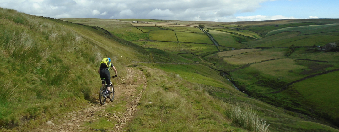
This mountain bike route of 29.5 miles starts from the Watergrove reservoir on the Mary Towneley Loop and Pennine Bridleway at the North East edge of Rochdale. The ride circles Todmorden and drops through three steep sided valleys on the way, which includes some fantastic riding on the famous packhorse trails of the area. Be careful though as, while there are lots of rocks, in the wet this ride can be quite muddy in parts.
1. Start from the car park at the Watergrove Reservoir (GR911176). Leave the car park through the gate on the right at the foot of the dam. Climb to the right hand end of the dam then turn left over the cattle grid to follow the edge of the reservoir. At the next junction, with a track on the right signposted as the Pennine Bridleway, turn right and climb the wide rocky track (GR912181). Go through the gate at the top then bear right and descend gently by the crenulated stone wall. Go straight on through the gate at the end of the wall and descend to the next junction, on a left hand bend with a wall on the right (GR923176).
2. Bear left and follow the main trail to the next junction at the entrance to a high valley. Bear left into the high valley then at the gated junction at the wall bear left and follow the wall to the gate at the far end. Once through the gate descend, bearing right, to a ford in a dip. Climb left out of the ford then continue left at a junction with a trail on the right (GR928182). Go straight on through the gate at the top and traverse the hillside to a gated junction by a farm. Go straight on through the gate and keep to the main trail for a descent that ends at a junction with a lane in the village of Calderbrook (GR942183).
3. Turn left and climb the lane out of the village to a three way junction where straight ahead leads up a long drive to a house (GR942185). Turn right and descend the lane through a left hand bend, then go between houses to a section of gritstone singletrack. Where it ends at a lane bear right and descend to a junction. Bear left and go a short distance on the flat to the next junction (GR944191). Turn left and climb the wide gravel track. At the next junction take the right hand fork and continue climbing the Pennine Bridleway up the tarmac double track. Go through the gate at the top and descend through some shallow bends, past the pylon, to a signposted Pennine Bridleway junction just before the track goes up a short climb (GR941203).
4. Turn right and descend the stone clad packhorse trail through the grass. This trail is quite eroded with long sections of mud and loose rocks. Go through a tight right hand bend at the gap in the wall then descend steeply through the following left hand hairpin. The descent finally finishes at a gate. Go through this gate and the one that follows a short distance later. Directly after the second gate turn right and descend the singletrack, keeping the hedge on the left. The track bears right to a traffic light controlled bridleway crossing at the main road (GR941206).
5. Go across the road then turn left and follow the path. At a junction with the second lane on the right turn sharp right (GR940208). Descend a short distance to then turn sharp left and ride past the cottages. At the junction just after turn right over the canal. At the junction on the other side go straight on and climb the very steep packhorse trail between the bushes. If it is dry and you’re very good at climbing it is possible to clean but for most it will be a push, it’s not that long though. Climb all the way to the gate at the top leading to the farm buildings (GR942211).
6. Turn left on the Pennine Bridleway to follow the track between the first and second buildings. After the gate descend to a stream crossing then climb to the left before descending right to a junction at the next house, on the left (GR940212). Bear right and climb another steep section of packhorse trail. Continue along this trail all the way to a gate at the top. Go through the gate then straight on along the lane, past the house. Descend through a number of bends to a junction on a left hand bend at the next group of houses (GR939217). Turn right and follow the lane past the entrance to a house. Continue straight on when the lane becomes a track and climb the more eroded pack horse trail over the shoulder of the hill. The track bears right to a junction at the top (GR938226). Continue ahead on the main trail for a fun descent on broken pack horse trail that finishes with a drop over a rock. After the drop continue straight on and descend the wide rocky track between the walls to a junction at the other end. Go straight across the crossroad junction and follow the singletrack to where it ends at a gate leading to a lane (GR945231).
7. After the gate turn right and descend the lane straight on all the way to the bottom of the dip, by the old mill in the village of Lumbutts. Follow the lane as it climbs right then left, past a chapel and out of the village. Climb straight on to a three way junction at the top then turn left to the next village. At the junction on the edge of the village directly after a garage on the right, turn right and follow the trail in the direction of Stoodley Pike monument (GR960234). Keep following the grit stone trail straight on as it traverses the hillside underneath the Stoodley Pike monument, going past two junctions with tracks on the left. After the second junction the trail bears right for a rocky climb to a junction just after going under some power lines. Go straight on and continue climbing. After a while bear left through a gate for the final part of the climb to a gate by a farm at the top (GR981248).
8. After the gate descend the track to the next junction and turn left. Descend this track to a junction with a gated grassy track on the right, opposite a wall that comes in from the left (GR981252). (Although on footpaths the next section is all concessional and legal for bikes). Turn right through the gate and ride along the grass, with a wall on the right and fence on the left. Follow the trail through a gate then through a tight S-bend to a junction with two gates at some trees. Go through the gate on the left and descend the hardpack track that follows the line of the stream on the left. Soon after entering the trees turn left at the three-way junction and descend to a gate. Go through the gate and cross the stream then bear right up a short, rocky climb to a junction at the top (GR980262). Turn right and descend the gravel track. Stay on the main track and ignore the muddy track that criss-crosses. The main track bears left before coming to a right hand hairpin at a house. Turn right through this hairpin then left through the next one. Continue descending, past a track on the left, then at the bottom bear right over the canal to the traffic lights at the main road (GR971264).
9. Turn right onto the main road and ride past the first arch under the railway on the left, signed for the Pennine Bridleway. Turn left under the third railway arch directly after the bus stop, signed for the ATC centre (GR974267). Directly after going through the arch turn right and climb the lane past a row of cottages on the left. At the next junction turn hard left then climb the right hand lane with the row of houses on the right. After leaving the houses climb through a right hand hairpin to a junction on the following left hand hairpin. Stay on the lane and climb left through the hairpin then up through a few more bends to a junction with a track to a farm on the right. Go straight on and climb between the houses to a junction directly after. Turn left and follow the lane a short distance to where it ends at a T-junction (GR967269). Turn right then climb past a lane on the left to a junction with a road at the top. Turn left and follow the road for a very short distance to a junction with track in the middle of the row of houses on the right, directly before a house on the left (GR964275).
10. Turn right and follow the Pennine Bridleway singletrack out the back of the houses to the top of the ridge. Be careful on the following steep and loose descent, it’s very fast and there are a big water bars at the bottom. At the bottom follow the tarmac to the left of the houses to the junction just after. Turn left and climb to a junction with a road (GR963281).
11. Turn left on the road and follow it up to a junction on the following left hand hairpin (GR959281). Go straight on and continuing climb on a wide track. Go straight on past the first house then at the second house continue straight on into the gravel parking area. Go through the gate in the far left hand corner and climb the singletrack through a grassy gully to a gated junction (GR948279). After the gate turn right and climb the track to a junction at a house on the left. Bear right and continue climbing. Go straight on, past a house on the right, up the grit stone double track to the top. After reaching the summit go down a short but fun descent to a junction (GR939286).
12. Turn left and follow the wide dirt track straight on to where it ends at a junction with a road (GR935273). Turn right and climb a short way to the next junction then turn left and descend the lane, which soon bears left and flattens off. At the third junction, a crossroad junction on a crest in the road before a big descent signed right to Todmorden, turn right (GR946266). Descend the lane through a 90 deg right hand bend, past some houses, to a junction on the following left hand bend (GR944261).
13. Go straight ahead along a flat section of broken packhorse trail. The track eventually bears right and descends to a stream crossing in a tight gully. Cross the stream and bear left then right up the climb to a junction with a lane (GR937261). Go straight on along the grassy double track to a gate. After the gate follow the vague track in an 11 o’clock direction across the moor. The trail soon becomes more a defined as a grassy, muddy and rocky descent that finishes with a steep rocky section to a junction by a gate on the right (GR932260).
14. Turn right through the gate and follow the stone paved packhorse trail. This becomes quite muddy before bearing left to a gate. Go through the gate and follow the trail down some drops between the stone walls. At the next junction go straight on, then after going between the derelict buildings climb the short rocky section. After the crest descend right then left to a gate. Once through the gate climb the grassy and muddy trail to a junction with the next track on the left, which may or may not have a gate (GR924655).
15. Turn left and descend the wide, rocky track that soon bears right to a junction (GR922262). Turn left and descend a short distance to a gate. After the gate go straight on down the wide track that bears left to a right hand hairpin. After going through the hairpin descend to a junction at the houses. Turn hard left and descend the broken road to a junction with the main road at the bottom (GR922255). Turn right and climb the main road through the villages. After leaving the houses behind and entering Lancashire turn sharp left over the grass and through a small gate signed as a bridleway immediately after a left hand bend in the main road (GR895267).
16. After the gate and climb the steep singletrack across the side of the valley. At the next junction turn right and climb the double track through a left hand bend to the junction immediately after. Turn right and climb the very steep double track. If you are a good at climbing it is possible to clean this climb but it’s not easy. At a building on the left the gradient becomes sensible again. Continue straight on all the way up the right hand side of the gully to a junction at the pylons at the top (GR887253). Turn left then go through the gate to climb the wide track over the crest of the hill. Descend to a four-way junction where the track ahead is blocked by boulders. Go straight on through the gap on the left of the boulders and follow the track to where it ends at the main road (GR890245).
17. Turn left and follow the main road over the crest then descend a short distance to a junction with a track on the right at the left hand bend (GR891241). Turn right then go past a track on the left to a forked junction. Bear slightly left on the track that comes to a gate soon after. Go through the gate then continue along the wide track for some time as it follows the line of the ridge on the right. The track eventually comes to a junction directly before a small quarried area straight on (GR902223). Turn right and climb the grassy and muddy track onto the top of the hill. Bear left at the top and follow the marker posts along the muddy and rutted track that leads to a gate at the trig point. Go through the gate then bear left and descend the grassy track, which soon becomes steep and muddy. Continue straight on until the track eventually bears left to a gate. Go through the gate and descend the wide rocky track down to a junction (GR913215). Turn sharp right and climb up the right hand side of the valley to a junction directly after a gate (GR910211).
18. Turn left and descend the grassy and muddy singletrack to the left of a gulley. Go through the stream crossing in the dip then after reaching the top of the next climb the trail bears slightly left and descends steeply to a gate. Directly after the gate go left over the bridge then push for a short distance up the loose, rocky track. The track soon becomes muddy, grassy and rideable. After a while the trail bears left to the top of the climb (GR914204).
19. After going over the ridge follow the singletrack as it bears right and descends towards Watergrove reservoir. Keep following the trail straight on to a junction with the double track (GR913195). Go straight on and descend the cobbled track. Continue going straight on to the junction by the reservoir directly after the second squeeze (GR911182). Turn left and follow the track as it bears right around the edge of the reservoir. Keep to the edge of the reservoir then after the cattle grid turn right around the end of the dam and descend back to the car park to complete the ride.