
Langthwaite and Reeth Moor
Yorkshire Mountain Bike Route Guide
Region:
Swaledale, The Yorkshire Dales
Difficulty:
Moderate
(For Experienced Riders)
Distance:
19 miles
Map:
OS Explorer OL30
Route Text Download:
Langthwaite and Reeth Moor
GPS Download:
GPX and KML
(available via the full MapMyRide page for this route, on the right hand side of the page)
Back to Yorkshire
Route Guides
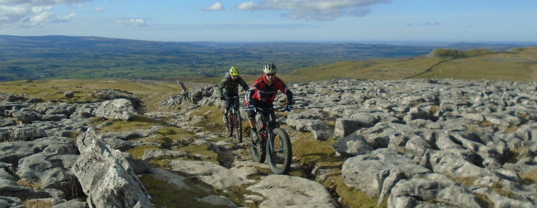
This mountain bike route of 19 miles is based around Reeth, at the junction of Swaledale and Akengarthdale in the Yorkshire Dales. It is split over two sections of different length each containing a big up and down. The first and largest section climbs from Langthwaite to the top of Reeth Moor before descending towards Reeth. After Reeth is the shorter, but more severe and technical, climb and descent of Fremington Edge. The trails go through a number of old earthworks and quarries so are predominantly rocky with a few sections of singletrack.
1. Start at the Red Lion in Langthwaite (GR005025). From the pub go over the bridge to the main road. Turn left and follow the road to Arkle Town. Just after the old petrol pumps and the first house take the bridleway on the right, up a gravel track (GR007019). Go through the gate to the left of the house and continue climbing the track to the B&B. Climb straight on past the B&B up the track, keeping the wall on the left. At the next track, at Bouldershaw House turn right and follow it a short distance to a junction with a road (GR995019). Turn left and climb the road. Go past a track on the right and descend the road through the ‘S’ bend to a ford at the bottom. Climb the road away from the ford and go past a track on the left. Just after the road starts descending again take the rocky double track off to the right (GR991005).
2. Follow the double track as it climbs for roughly 2 miles to the disused mine works at Surrender Ground (GR971024). Follow the track to the left as it winds its way down through the rock piles of Forefield Rake. The track eventually steepens, turns left and comes to a gate (GR960022). Once through the gate follow the rocky track through a number of dips by Fincher Gill to a junction at a gate. Go straight on and follow the wide track through the old mine workings to the road at Surrender Bridge (GR988999).
3. Turn left and climb the road from the bridge. At the top go past the previously taken track on the left. Descend to the ford then climb to a junction at the second hairpin (GR992009). Go through the gate on the the right immmediately after follow the singletrack to the right of the double track. Keep to the singletrack as it climbs along to the right hand side of Cringley Hill. Eventually the track starts descending with some rocky bends. After the rocks go straight on, along the grassy singletrack, where a wide track seems to turn off to gate on the right. Follow the singletrack across the bottom of a drystone walled enclosure on the left then bear slightly right to a four-way junction with a rocky double track (GR005999).
5. Go straight across the double track and continue descending on the grassy double track to the right of another drystone walled enclosure. The track turns left below the enclosure and descends toward a wall on the right hand side. Go straight across the track leading off to the left and continue following the wall on the right. Go down a tight section of trail, through a right then left hand (GR007996) bend to a gate. After the gate go right through the field to a gate leading into the trees. Aftre the gate follow the track left through the trees, then go straight on at the next junction and descend the gravel track to a lane (GR014989).
6. Turn left and follow the lane to the junction with the B6270. Turn right and follow the main road towards Gunnerside. In just under 1 mile turn left over the stone bridge signed to Askrigg (GR006984). After crossing the bridge turn left and follow the lane as it climbs to the signed bridleway descending to a gate on the left (GR015983). Follow the bridleway through the gate then descend through the field to a gate on the right. Go through the gate and follow a thin track high above the river, below on the left, until it quickly drops left to the next gate on the river bank. Go through the gate and follow the winding singletrack to a short paved section right by the river (probably liable to flooding) then continue along more singletrack to the next gate (GR027989).
7. After the gate drop off the singletrack on the raised bank to a grassy track on the right. This parallels the bank for a while before bearing slightly right where the river turns left. Cut across the field to a gate in the right hand side of the fence in front. After the gate go onto the double track on the right then follow it left, keeping to the drystone wall on the left. Continue along the double track until a 90deg left hand turn towards a bridge. At this point go straight ahead on the grass along the track that passes close to the river then comes to a gate, where the track climbs between the drystone walls. Follow the track between the walls, through a few gates, to a final short climb to a lane. Turn left and follow the tarmac to a junction in Grinton (GR047984).
8. At the junction turn left to a junction with the main road by the Bridge Inn. Go straight on and cross the bridge to a junction with the second lane on the right on the left hand bend (GR044990). Turn right and climb the steep road that bears right into Fremington. At the junction in the village turn left. Climb the road out of Fremington and past a bridleway on the left (GR046993). Continue up the lane to a gate near a white house on the left. Climb past the house on the trail that turns from tarmac to a loose, rocky dirt track. At this point the trail steepens and, combined with bedrock covered in loose rocks, becomes a real challenge to clean. Near the top take the left hand trail which then bears right for a short technical finish before it flattens out and comes to a gate (GR044007).
9. After the gate follow the wide rocky track down hill. At the bottom of the trail go through the two gates to the junction by a house (GR046023). Turn left through the two closely set gates and climb the wide rocky track through the old earthworks. Go past the tracks on the right and climb to an S-bend at the top. There is a bridleway marked on the map just before this S-bend but there isn’t anything on the ground. Follow the S-bend to the top of the hill then after the crest take the double track on the left through the heather. This comes out at a gate (GR032021).
10. Go through the gate and follow the grassy singletrack straight on. This opens up and gets progressively faster as it approaches the top of an old quarry. Follow the cairns through the gravel then, after skirting round the left of a small spoil heap, bear right down a short rocky chute for a wide and fast gassy descent. Beware of the ditch halfway down, too much speed and braking on grass could end unhappily. After reaching a rocky track, follow it left for an exposed traverse across the top of the quarry. At the far side of the quarry drop through a tight, rocky right hand turn. Ride across the bottom of the quarry where the trail then becomes grassy before reaching a gate in the drystone wall on the left (GR019024).
11. Go through the gate and descend through a number of bends on the increasingly rocky track that comes out at a gate near Storthwaite Hall at the bottom (GR018021). Turn right and follow the wide track through a left hand bend and, after a gate, up the broken concrete. Continue along this track, going straight on at the next junction, then keep the river on the left and ride all the way back into Langthwaite to complete the ride.